IMAGES TAKEN NEAR TO
Frances Way, IBSTOCK, LE67 6DA
Introduction
This page details the photographs taken nearby to Frances Way, LE67 6DA by members of the Geograph project.
The Geograph project started in 2005 with the aim of publishing, organising and preserving representative images for every square kilometre of Great Britain, Ireland and the Isle of Man.

There are currently over 7.5m images from over14,400 individuals and you can help contribute to the project by visiting https://www.geograph.org.uk
Image Map
Images are licensed for reuse under creativecommons.org/licenses/by-sa/2.0
Notes
- Clicking on the map will re-center to the selected point.
- The higher the marker number, the further away the image location is from the centre of the postcode.
Image Listing (12 Images Found)
Images are licensed for reuse under creativecommons.org/licenses/by-sa/2.0
Image
Details
Distance
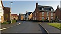
3
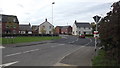
Frances Way, Ibstock
New housing off Ravenstone Road.
Image: © JThomas
Taken: 27 Jun 2019
0.08 miles
5
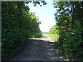
Byway off Ravenstone Road, Ibstock
Also the National Forest Way Path.
Image: © JThomas
Taken: 27 Jun 2019
0.15 miles
7
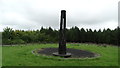
Scene Valley Forest Park - Noon column
A type of modern day sundial. The sun is suppose to shine through the slit at midday but not on this occasion. There are several of these type structures in the National Forest.
Image: © Colin Park
Taken: 21 Aug 2017
0.18 miles
8
Usbourne Way, Ibstock
A new housing estate on the edge of Ibstock
Image: © John Welford
Taken: 23 Sep 2015
0.19 miles
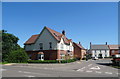
9
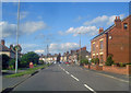
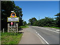
Bend in Melbourne Road
Main village street bending off to the left.
Image: © Trevor Rickard
Taken: 15 Aug 2009
0.19 miles
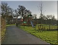
10
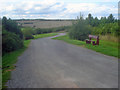
Path down to the lakes at Sence Valley Forest Park
Heading north to the hairpin which leads left to the lakes at the bottom of the valley. Now part of the National Forest, it is hard to believe that this area was part of the open cast mine, which between 1982 and 1996 produced eight million tons of coal for nearby power stations.
http://www.forestry.gov.uk/website/recreation.nsf/LUWebDocsByKey/EnglandDerbyshireTheNationalForestSenceValley
Image: © Trevor Rickard
Taken: 15 Aug 2009
0.24 miles