IMAGES TAKEN NEAR TO
Talbot Street, COALVILLE, LE67 5AY
Introduction
This page details the photographs taken nearby to Talbot Street, LE67 5AY by members of the Geograph project.
The Geograph project started in 2005 with the aim of publishing, organising and preserving representative images for every square kilometre of Great Britain, Ireland and the Isle of Man.

There are currently over 7.5m images from over14,400 individuals and you can help contribute to the project by visiting https://www.geograph.org.uk
Image Map
Images are licensed for reuse under creativecommons.org/licenses/by-sa/2.0
Notes
- Clicking on the map will re-center to the selected point.
- The higher the marker number, the further away the image location is from the centre of the postcode.
Image Listing (15 Images Found)
Images are licensed for reuse under creativecommons.org/licenses/by-sa/2.0
Image
Details
Distance
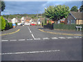
1
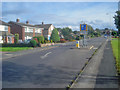
Traffic calming on Talbot Street
Looking south-east towards Whitwick. There are a whole series of these chicanes along the main route through Thringstone-Whitwick.
Image: © Trevor Rickard
Taken: 29 Aug 2009
0.02 miles
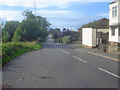
2
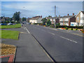
Talbot Street
Looking north-west towards Thringstone.
Image: © Trevor Rickard
Taken: 29 Aug 2009
0.04 miles
3
West end of Gracedieu Road, Thringstone
Seen at its junction with Talbot Street on the southern edge of Thringstone. Gracedieu was a nearby priory, some of whose ruined walls still stand.
Image: © Richard Vince
Taken: 27 Mar 2013
0.06 miles
4
Carter Dale estate
View east off Talbot Street down the entrance to a cluster of residential streets.
Image: © Trevor Rickard
Taken: 29 Aug 2009
0.07 miles
5
Talbot Lane
Heading north-west along the road to Peggs Green.
Image: © Trevor Rickard
Taken: 29 Aug 2009
0.07 miles
6
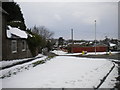
South end of Talbot Lane, Whitwick
Seen from Talbot Street on the southern approach to Thringstone. There had apparently been precious little warmth or sunshine here since the snow arrived earlier in the week.
Image: © Richard Vince
Taken: 27 Mar 2013
0.08 miles
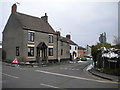
7
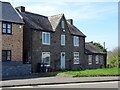
The former Talbot Arms Inn
The Talbot Arms ceased to be an inn in 1931.
Image: © Ian Calderwood
Taken: 4 Apr 2021
0.10 miles
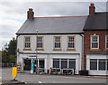
8
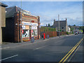
Thringstone Post Office
Situated on The Green. Post office, off licence, newsagents, and does a nice line in potted plants.
Image: © Trevor Rickard
Taken: 29 Aug 2009
0.13 miles
9
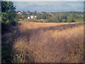
Rape crop near Thringstone - 2
Looking north down the public footpath to houses at Thringstone. Grace Dieu Wood on the right.
Image: © Trevor Rickard
Taken: 29 Aug 2009
0.13 miles