IMAGES TAKEN NEAR TO
Fulton Drive, COALVILLE, LE67 3NN
Introduction
This page details the photographs taken nearby to Fulton Drive, LE67 3NN by members of the Geograph project.
The Geograph project started in 2005 with the aim of publishing, organising and preserving representative images for every square kilometre of Great Britain, Ireland and the Isle of Man.

There are currently over 7.5m images from over14,400 individuals and you can help contribute to the project by visiting https://www.geograph.org.uk
Image Map
Images are licensed for reuse under creativecommons.org/licenses/by-sa/2.0
Notes
- Clicking on the map will re-center to the selected point.
- The higher the marker number, the further away the image location is from the centre of the postcode.
Image Listing (4 Images Found)
Images are licensed for reuse under creativecommons.org/licenses/by-sa/2.0
Image
Details
Distance
1
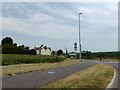
Shared path at Hoo Ash roundabout
The shared cycle- and foot-path runs beside the A511; the restrictions (30mph and 7.5t for vehicles) do not apply to bicycles, even though the sign is alongside the path. The Swannington sign notes that it is in the National Forest
Image: © David Smith
Taken: 12 Jun 2015
0.18 miles
2
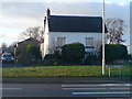
On the edge
Hoo Ash Farm is right on the edge of this grid square, the farmhouse is in and its outbuildings are in the next square.
Image: © cris sloan
Taken: 10 Jan 2007
0.19 miles
4
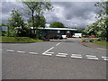
Stephenson Court
Part of a larger industrial area is Stephenson Court. The busy A511 road runs just behind the units.
Image: © Michael Patterson
Taken: 24 May 2006
0.24 miles