IMAGES TAKEN NEAR TO
Oxford Street, COALVILLE, LE67 3GS
Introduction
This page details the photographs taken nearby to Oxford Street, LE67 3GS by members of the Geograph project.
The Geograph project started in 2005 with the aim of publishing, organising and preserving representative images for every square kilometre of Great Britain, Ireland and the Isle of Man.

There are currently over 7.5m images from over14,400 individuals and you can help contribute to the project by visiting https://www.geograph.org.uk
Image Map
Images are licensed for reuse under creativecommons.org/licenses/by-sa/2.0
Notes
- Clicking on the map will re-center to the selected point.
- The higher the marker number, the further away the image location is from the centre of the postcode.
Image Listing (20 Images Found)
Images are licensed for reuse under creativecommons.org/licenses/by-sa/2.0
Image
Details
Distance
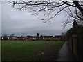
2
Site of Coalville LNWR station, 1988
View northward, towards Loughborough: ex-LNWR Nuneaton - Loughborough (Derby Road) (Charnwood Forest) line, closed 14/4/31.
Image: © Ben Brooksbank
Taken: 7 Jun 1988
0.11 miles
3
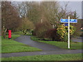
Charnwood Street, Coalville
A residential street running north from London Road just under a mile east of the town centre.
Image: © Richard Vince
Taken: 27 Mar 2013
0.12 miles
4
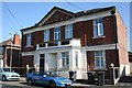
The Leicestershire Miners' Association building
The Leicestershire Miners' Association building at 8 Bakewell Street, Coalville. Now home to Stirling Solutions who produce software for the road haulage industry.
Image: © Les Carruthers
Taken: 21 Sep 2006
0.12 miles
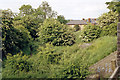
5
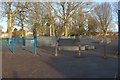
Cycle route built on the course of the Charnwood Forest Railway
Looking towards the site of Coalville East station
Image: © Tim Glover
Taken: 5 Jan 2018
0.13 miles
6
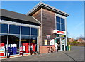
Spar store in Coalville
This new Spar store along Broom Leys Road was opened in 2013.
Image: © Mat Fascione
Taken: 8 Feb 2015
0.13 miles
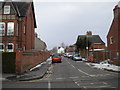
8
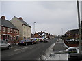
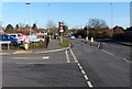
Traffic lights on London Road, Coalville
The junction of London Road with Broom Leys Road (left) and Forest Road (right), about a mile east of Coalville town centre. The new housing on the left is still under construction; the site continues around the corner along Broom Leys Road.
Image: © Richard Vince
Taken: 27 Mar 2013
0.15 miles
9
Broom Leys Road in Coalville
At the junction with Fox Leys Drive.
Image: © Mat Fascione
Taken: 8 Feb 2015
0.15 miles
10
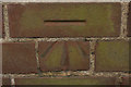
Cut Bench Mark, London Road Cemetery
Bench Mark Database: http://www.bench-marks.org.uk/bm43865
Image: © Mark Anderson
Taken: 10 Jul 2012
0.16 miles