IMAGES TAKEN NEAR TO
Albert Road, COALVILLE, LE67 3AA
Introduction
This page details the photographs taken nearby to Albert Road, LE67 3AA by members of the Geograph project.
The Geograph project started in 2005 with the aim of publishing, organising and preserving representative images for every square kilometre of Great Britain, Ireland and the Isle of Man.

There are currently over 7.5m images from over14,400 individuals and you can help contribute to the project by visiting https://www.geograph.org.uk
Image Map
Images are licensed for reuse under creativecommons.org/licenses/by-sa/2.0
Notes
- Clicking on the map will re-center to the selected point.
- The higher the marker number, the further away the image location is from the centre of the postcode.
Image Listing (9 Images Found)
Images are licensed for reuse under creativecommons.org/licenses/by-sa/2.0
Image
Details
Distance
2
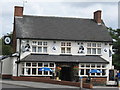
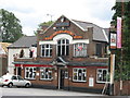
Coalville Victoria Pub
Bikers pub on Whitwick Road.
Image: © the bitterman
Taken: 1 Aug 2010
0.15 miles
4
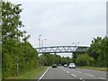
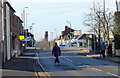
Footbridge over Stephenson Way, Coalville by-pass
Image: © David Smith
Taken: 12 Jun 2015
0.19 miles
5
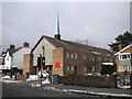
Church of St Wilfrid of York, Coalville
A Roman Catholic church, situated on London Road a little way east of the town centre.
Image: © Richard Vince
Taken: 27 Mar 2013
0.21 miles
6
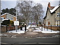
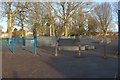
Coalville Park entrance, London Road
There are two pedestrian entrances to Coalville Park from London Road, located around 100 yards apart; this is the eastern one.
Image: © Richard Vince
Taken: 27 Mar 2013
0.22 miles
8
Coalville Leicester Inn
4 London Road.
Image: © the bitterman
Taken: 1 Aug 2010
0.24 miles
9
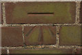
Cut Bench Mark, London Road Cemetery
Bench Mark Database: http://www.bench-marks.org.uk/bm43865
Image: © Mark Anderson
Taken: 10 Jul 2012
0.24 miles