IMAGES TAKEN NEAR TO
Highfields Close, COALVILLE, LE67 2TN
Introduction
This page details the photographs taken nearby to Highfields Close, LE67 2TN by members of the Geograph project.
The Geograph project started in 2005 with the aim of publishing, organising and preserving representative images for every square kilometre of Great Britain, Ireland and the Isle of Man.

There are currently over 7.5m images from over14,400 individuals and you can help contribute to the project by visiting https://www.geograph.org.uk
Image Map
Images are licensed for reuse under creativecommons.org/licenses/by-sa/2.0
Notes
- Clicking on the map will re-center to the selected point.
- The higher the marker number, the further away the image location is from the centre of the postcode.
Image Listing (31 Images Found)
Images are licensed for reuse under creativecommons.org/licenses/by-sa/2.0
Image
Details
Distance
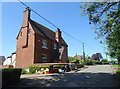
2
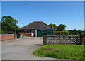
Bungalow on Main Street, Normanton le Heath
Image: © JThomas
Taken: 27 Jun 2019
0.05 miles
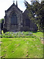
3
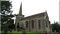
Normanton le Heath, Leics - Holy Trinity Church
Image: © Colin Park
Taken: 21 Aug 2017
0.06 miles
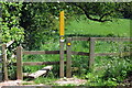
4
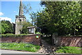
Holy Rood Church
The green sign by the gate is for a defibrillator.
Image: © Philip Jeffrey
Taken: 26 May 2013
0.06 miles
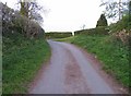
5
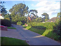
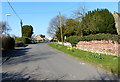
Main Street
Looking north to the right turn to The Hollow.
Image: © Trevor Rickard
Taken: 15 Aug 2009
0.07 miles
6
The Main Street of Normanton le Heath
On the right is Holy Trinity Church.
Image: © Mat Fascione
Taken: 20 Apr 2013
0.07 miles
7
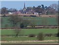
Normanton le Heath
Viewed from across the fields near Measham Hall.
Image: © Mat Fascione
Taken: 20 Apr 2013
0.08 miles