IMAGES TAKEN NEAR TO
School Lane, COALVILLE, LE67 2SL
Introduction
This page details the photographs taken nearby to School Lane, LE67 2SL by members of the Geograph project.
The Geograph project started in 2005 with the aim of publishing, organising and preserving representative images for every square kilometre of Great Britain, Ireland and the Isle of Man.

There are currently over 7.5m images from over14,400 individuals and you can help contribute to the project by visiting https://www.geograph.org.uk
Image Map
Images are licensed for reuse under creativecommons.org/licenses/by-sa/2.0
Notes
- Clicking on the map will re-center to the selected point.
- The higher the marker number, the further away the image location is from the centre of the postcode.
Image Listing (44 Images Found)
Images are licensed for reuse under creativecommons.org/licenses/by-sa/2.0
Image
Details
Distance
1
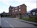
Newton Burgoland, Leics
Swish residences converted from a former mill.
Image: © Tony Teperek
Taken: 2 Mar 2006
0.02 miles
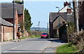
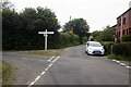
3

Newton Burgoland
Looking along Odstone Lane into the village centre.
Image: © Christine Johnstone
Taken: 13 Mar 2011
0.03 miles
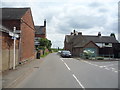
4
Main Street, Newton Burgoland
Looking south east.
Image: © JThomas
Taken: 21 Jul 2016
0.03 miles
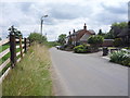
5
Newton Burgoland
Looking out of the village along Odstone Lane.
Image: © Christine Johnstone
Taken: 13 Mar 2011
0.04 miles
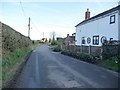
8
Road junction on Main Street, Newton Burgoland
Image: © JThomas
Taken: 21 Jul 2016
0.06 miles
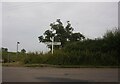
9
Footpath to the left
The footpath towards Heather leaving Odstone Lane.
Image: © Christine Johnstone
Taken: 13 Mar 2011
0.06 miles
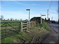
10
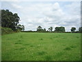
Grazing, Newton Burgoland
Off Main Street.
Image: © JThomas
Taken: 21 Jul 2016
0.06 miles