IMAGES TAKEN NEAR TO
Ravenslea, COALVILLE, LE67 2JZ
Introduction
This page details the photographs taken nearby to Ravenslea, LE67 2JZ by members of the Geograph project.
The Geograph project started in 2005 with the aim of publishing, organising and preserving representative images for every square kilometre of Great Britain, Ireland and the Isle of Man.

There are currently over 7.5m images from over14,400 individuals and you can help contribute to the project by visiting https://www.geograph.org.uk
Image Map
Images are licensed for reuse under creativecommons.org/licenses/by-sa/2.0
Notes
- Clicking on the map will re-center to the selected point.
- The higher the marker number, the further away the image location is from the centre of the postcode.
Image Listing (14 Images Found)
Images are licensed for reuse under creativecommons.org/licenses/by-sa/2.0
Image
Details
Distance
1
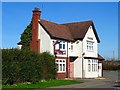
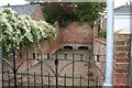
The Plough
The Plough has been shut for some time and is the subject to a planning application for "Conversion of existing public house and associated outbuilding along with the erection of new buildings to form 9 residential dwellings".
Image: © Ian Calderwood
Taken: 24 Mar 2017
0.03 miles
2
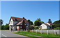
The former Plough public house, Ravenstone
On Jenny's Lane.
Earmarked for housing.
Image: © JThomas
Taken: 27 Jun 2019
0.03 miles
3
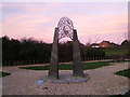
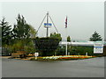
Ravens & stones
Interesting modern feature in Ravenstone, with mandatory Ravens, set against a colourful dawn sky.
Image: © cris sloan
Taken: 11 Mar 2007
0.07 miles
4
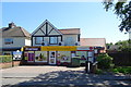
Ravenstone Convenience Store and Post Office
On Leicester Road.
Image: © JThomas
Taken: 27 Jun 2019
0.09 miles
5
Ravenstone Pinfold
A pinfold, in Ashby Road, Ravenstone. Now sandwiched between recent houses. This ancient enclosure was used to hold stray animals found in the parish. It was renovated in 1982 by students of Coalville Technical College.
Image: © Nigel Aspdin
Taken: 20 Oct 2009
0.17 miles
6
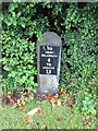
Milestone, Ravenstone
Carved stone post with metal attachment, on the UC road, in the parish of Ravenstone with Snibston (North-West Leicestershire District); Leicester Road, next to village institute, against hedge, on South side of road. The inscription reads: // TO / ASHBY / DELAZOUCH / 4 / TO / LEICESTER / 13 //. C19, erected by the Ashby-de-la-Zouch Turnpike Trust. Not listed by Historic England. Part of a national survey of wayside features by the Milestone Society: https://www.milestonesociety.co.uk/ Milestone Society ID: LE_AZLE04.
Image: © Elliott Hill
Taken: 8 Jun 2019
0.17 miles
7
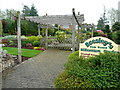
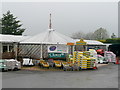
Beesley's Garden Centre, Ravenstone 2
Millennium Garden adjacent to the car park.
Image: © Jonathan Billinger
Taken: 16 Apr 2009
0.20 miles
9
Beesley's Garden Centre, Ravenstone 3
The Midlands' largest Hanging basket, constructed to raise funds for the Coalville Community Hospital Stroke Unit.
Image: © Jonathan Billinger
Taken: 16 Apr 2009
0.21 miles
10
Beesley's Garden Centre, Ravenstone 1
View of the entrance.
Image: © Jonathan Billinger
Taken: 16 Apr 2009
0.21 miles