IMAGES TAKEN NEAR TO
Farm Close, COALVILLE, LE67 2HH
Introduction
This page details the photographs taken nearby to Farm Close, LE67 2HH by members of the Geograph project.
The Geograph project started in 2005 with the aim of publishing, organising and preserving representative images for every square kilometre of Great Britain, Ireland and the Isle of Man.

There are currently over 7.5m images from over14,400 individuals and you can help contribute to the project by visiting https://www.geograph.org.uk
Image Map
Images are licensed for reuse under creativecommons.org/licenses/by-sa/2.0
Notes
- Clicking on the map will re-center to the selected point.
- The higher the marker number, the further away the image location is from the centre of the postcode.
Image Listing (3 Images Found)
Images are licensed for reuse under creativecommons.org/licenses/by-sa/2.0
Image
Details
Distance
1
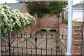
Ravenstone Pinfold
A pinfold, in Ashby Road, Ravenstone. Now sandwiched between recent houses. This ancient enclosure was used to hold stray animals found in the parish. It was renovated in 1982 by students of Coalville Technical College.
Image: © Nigel Aspdin
Taken: 20 Oct 2009
0.14 miles
3
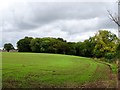
Spring Wood
There is a spring in the wood, which feeds into Blower's Brook.
Image: © Ian Calderwood
Taken: 21 Oct 2016
0.18 miles