IMAGES TAKEN NEAR TO
Midland Road, COALVILLE, LE67 2FX
Introduction
This page details the photographs taken nearby to Midland Road, LE67 2FX by members of the Geograph project.
The Geograph project started in 2005 with the aim of publishing, organising and preserving representative images for every square kilometre of Great Britain, Ireland and the Isle of Man.

There are currently over 7.5m images from over14,400 individuals and you can help contribute to the project by visiting https://www.geograph.org.uk
Image Map
Images are licensed for reuse under creativecommons.org/licenses/by-sa/2.0
Notes
- Clicking on the map will re-center to the selected point.
- The higher the marker number, the further away the image location is from the centre of the postcode.
Image Listing (12 Images Found)
Images are licensed for reuse under creativecommons.org/licenses/by-sa/2.0
Image
Details
Distance
1
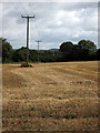
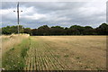
Farmland between Hugglescote and Ellistown
On the horizon is Bardon Hill, the highest point in Leicestershire, its summit is 278 m (912 ft) above sea level.
Image: © Mat Fascione
Taken: 8 Feb 2015
0.09 miles
2
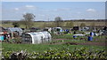
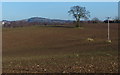
Site of Hugglescote station
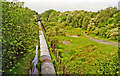
View westward, towards Nuneaton: ex-LNW & Midland (Nuneaton & Ashby) Joint Railway, Shackerston Junction - Coalville - Loughborough (Derby Road) branch. The station and line closed to passenger traffic from 13/4/31, but goods continued until 6/4/64. Here the track-bed is occupied by a conveyor bringing coal from an overcast site (see http://www.bbc.co.uk/history/domesday/dblock/GB-440000-309000/page/4 ), probably to the Ellistown industrial siding SE of Coalville.
Image: © Ben Brooksbank
Taken: 29 May 1995
0.09 miles
3
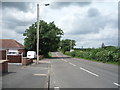
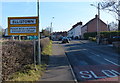
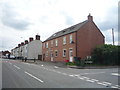
Midland Road, Ellistown
Looking north west.
Image: © JThomas
Taken: 21 Jul 2016
0.15 miles