IMAGES TAKEN NEAR TO
Hatter Close, LE67 2ES
Introduction
This page details the photographs taken nearby to Hatter Close, LE67 2ES by members of the Geograph project.
The Geograph project started in 2005 with the aim of publishing, organising and preserving representative images for every square kilometre of Great Britain, Ireland and the Isle of Man.

There are currently over 7.5m images from over14,400 individuals and you can help contribute to the project by visiting https://www.geograph.org.uk
Image Map
Images are licensed for reuse under creativecommons.org/licenses/by-sa/2.0
Notes
- Clicking on the map will re-center to the selected point.
- The higher the marker number, the further away the image location is from the centre of the postcode.
Image Listing (12 Images Found)
Images are licensed for reuse under creativecommons.org/licenses/by-sa/2.0
Image
Details
Distance
2
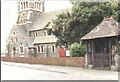
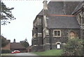
St. John the Baptist Church
Grange Road, Hugglescote
Image: © Steve Rowe
Taken: 8 Sep 2007
0.20 miles
3
St. John the Baptist Church in Hugglescote
Image: © Mat Fascione
Taken: 8 Feb 2015
0.21 miles
5

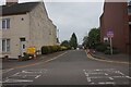
Grange View Housing Development
Photograph taken on Grange Road, Hugglescote. October 2021. Taken from as near as possible to the viewpoint of a previous picture in July 2018 when all that was visible was Hugglesote Surgery (on the left ) and farming land.
Image: © Jim Messenger
Taken: 9 Oct 2021
0.22 miles
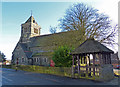
6
St. John the Baptist Church
This is the south side of the church.
Image: © Steve Rowe
Taken: 8 Sep 2007
0.22 miles
7
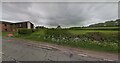
Site of planned Grange View Building Development
Photograph from Grange Road of fields that will be developed into the Grange View housing estate. Taken approx 2018. On the left is the Hugglescote Surgery. This view is roughly where the entrance to Percival Road will be built in 2020.
Image: © Google Maps
Taken: 1 Jul 2018
0.23 miles
9
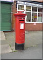
Edward VIII postbox on Central Road, Hugglescote
Postbox No. LE67 297 outside the former Post Office.
Because Edward VIII was king for only 326 days, postboxes bearing his cypher are thin on the ground, there being only around 150 survivors in the whole of the UK.
See Image] for context.
Image: © JThomas
Taken: 21 Jul 2016
0.23 miles
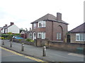
10
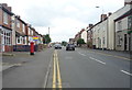
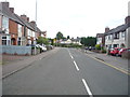
Central Road, Hugglescote
Looking north showing position of Postbox No. LE67 297 outside the former Post Office.
Because Edward VIII was king for only 326 days, postboxes bearing his cypher are thin on the ground, there being only around 150 survivors in the whole of the UK.
See Image] for postbox.
Image: © JThomas
Taken: 21 Jul 2016
0.23 miles