IMAGES TAKEN NEAR TO
Ibstock Road, COALVILLE, LE67 2AN
Introduction
This page details the photographs taken nearby to Ibstock Road, LE67 2AN by members of the Geograph project.
The Geograph project started in 2005 with the aim of publishing, organising and preserving representative images for every square kilometre of Great Britain, Ireland and the Isle of Man.

There are currently over 7.5m images from over14,400 individuals and you can help contribute to the project by visiting https://www.geograph.org.uk
Image Map
Images are licensed for reuse under creativecommons.org/licenses/by-sa/2.0
Notes
- Clicking on the map will re-center to the selected point.
- The higher the marker number, the further away the image location is from the centre of the postcode.
Image Listing (6 Images Found)
Images are licensed for reuse under creativecommons.org/licenses/by-sa/2.0
Image
Details
Distance
1
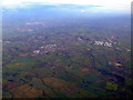
Coalville from the air
Coalville is in the centre, with Ravenstone nearer the camera. Several large quarries are also visible. Taken from a Prague bound flight from East Midlands.
Image: © Thomas Nugent
Taken: 5 Dec 2011
0.05 miles
2
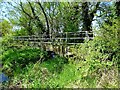
Footbridge by the bridleway ford
Horse riders seem to use an informal ford, here, rather than crossing the rather-overgrown footbridge.
Image: © Ian Calderwood
Taken: 4 May 2017
0.13 miles
3
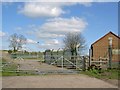
Track to Berryhills Farm
Off Melbourne Road.
Image: © JThomas
Taken: 27 Jun 2019
0.21 miles
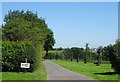
5
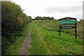
Entrance to Kelham Bridge Forest walk
Image: © Steve Fareham
Taken: 17 Apr 2008
0.24 miles