IMAGES TAKEN NEAR TO
Main Street, COALVILLE, LE67 1DN
Introduction
This page details the photographs taken nearby to Main Street, LE67 1DN by members of the Geograph project.
The Geograph project started in 2005 with the aim of publishing, organising and preserving representative images for every square kilometre of Great Britain, Ireland and the Isle of Man.

There are currently over 7.5m images from over14,400 individuals and you can help contribute to the project by visiting https://www.geograph.org.uk
Image Map
Images are licensed for reuse under creativecommons.org/licenses/by-sa/2.0
Notes
- Clicking on the map will re-center to the selected point.
- The higher the marker number, the further away the image location is from the centre of the postcode.
Image Listing (31 Images Found)
Images are licensed for reuse under creativecommons.org/licenses/by-sa/2.0
Image
Details
Distance
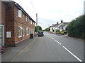
1
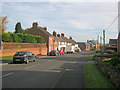
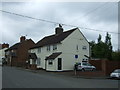
Main Street
View east along the village street.
Image: © Trevor Rickard
Taken: 30 Oct 2010
0.01 miles
2
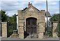
The Bier House in Bagworth, Leicestershire
Image: © Mat Fascione
Taken: 27 Aug 2007
0.03 miles
3
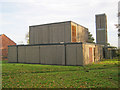
Holy Rood Church at Bagworth
The original Norman church on this site suffered from mining subsidence and was demolished in 1968. The replacement church is this prefabricated concrete building, which does contain some of the original Norman stonework. Has all the hallmarks of a 'progressive' 1960s building and in my opinion this must rate as one of the ugliest churches in the country.
http://www.leicestershirechurches.co.uk/#/bagworth-church-leicestershire/4533897259
Image: © Trevor Rickard
Taken: 30 Oct 2010
0.04 miles
4
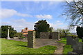
Site of the former Church of the Holy Rood, Bagworth
The original church, dating back to Norman times, suffered from subsidence caused by coal mining, and was demolished in 1968.
Image: © Tim Heaton
Taken: 6 Apr 2019
0.05 miles
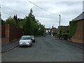
6
View east towards the village of Thornton
Manor Farm is in Bagworth and is part of the National Forest.
Image: © Mat Fascione
Taken: 8 Feb 2015
0.06 miles
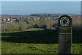
8
The Ivanhoe Way, Bagworth
The Ivanhoe Way is a 35 mile walk around the north west of Leicestershire.
Image: © Mat Fascione
Taken: 27 Aug 2007
0.08 miles
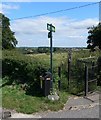
10
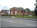
Elizabeth II postbox on Main Street, Bagworth
Postbox No. LE67 58.
See Image] for close up.
Image: © JThomas
Taken: 21 Jul 2016
0.10 miles