IMAGES TAKEN NEAR TO
Willesley Wood Side, ASHBY-DE-LA-ZOUCH, LE65 2UP
Introduction
This page details the photographs taken nearby to Willesley Wood Side, LE65 2UP by members of the Geograph project.
The Geograph project started in 2005 with the aim of publishing, organising and preserving representative images for every square kilometre of Great Britain, Ireland and the Isle of Man.

There are currently over 7.5m images from over14,400 individuals and you can help contribute to the project by visiting https://www.geograph.org.uk
Image Map
Images are licensed for reuse under creativecommons.org/licenses/by-sa/2.0
Notes
- Clicking on the map will re-center to the selected point.
- The higher the marker number, the further away the image location is from the centre of the postcode.
Image Listing (6 Images Found)
Images are licensed for reuse under creativecommons.org/licenses/by-sa/2.0
Image
Details
Distance
3
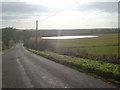
A new lake
Looking down Woodside towards Willesley crossroads, this new expanse of water has been formed after the recent opencast workings had ceased.
Image: © cris sloan
Taken: 11 Nov 2006
0.13 miles
5
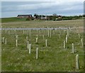
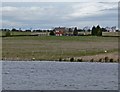
Hill Farm
With newly planted trees and a new lake in the foreground.
Image: © Mat Fascione
Taken: 26 Apr 2008
0.19 miles
6
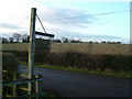
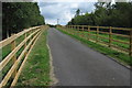
Appropriate
With the sign for Wood Farm in the foreground, all around is being planted with trees. How fitting.....
Image: © cris sloan
Taken: 7 Mar 2007
0.19 miles