IMAGES TAKEN NEAR TO
Castle Way, ASHBY-DE-LA-ZOUCH, LE65 2RY
Introduction
This page details the photographs taken nearby to Castle Way, LE65 2RY by members of the Geograph project.
The Geograph project started in 2005 with the aim of publishing, organising and preserving representative images for every square kilometre of Great Britain, Ireland and the Isle of Man.

There are currently over 7.5m images from over14,400 individuals and you can help contribute to the project by visiting https://www.geograph.org.uk
Image Map (Loading...)


Getting Data...Please wait
Leaflet Map data © OpenStreetMap
Images are licensed for reuse under creativecommons.org/licenses/by-sa/2.0
Notes
- Clicking on the map will re-center to the selected point.
- The higher the marker number, the further away the image location is from the centre of the postcode.
Image Listing (51 Images Found)
Images are licensed for reuse under creativecommons.org/licenses/by-sa/2.0
Image
Details
Distance
1
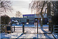
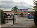
Ashby Willesley Primary School
A primary school on the outskirts of Ashby, and located next to Western Park. It is closed here, because of heavy snow coverage.
Image: © Oliver Mills
Taken: 11 Dec 2017
0.04 miles
2
Willesley Primary School, Ashby
The school at the end of Packington Nook lane (before the farm track part; Image). The painting is an exhibit from the Ashby Arts Festival.
Image: © Oliver Mills
Taken: 24 Jun 2016
0.04 miles
3
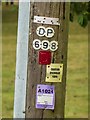
Signage on an imperfect telegraph pole, Packington Nook Lane, Ashby-de-la-Zouch
This 1964 telegraph pole can be seen in its full entirety here Image From top to bottom, the signage represents: The most recent inspection date and type (entirely faded); the sequential Distribution Point identifier; the D plate (decayed; unsuitable to climb by ladder); what is presumably a warning to kite-flyers; and an "A1024" notice (contents is entirely faded), which directly instructs for the pole's imminent repair or replacement
Image: © Oliver Mills
Taken: 6 Aug 2020
0.05 miles
4
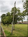
A telegraph pole in need of attention, Packington Nook Lane, Ashby-de-la-Zouch
This telegraph pole was installed by GPO in 1964, 30" tall, and classified as a "light" pole. Its noticeable lean appears to have earned it both a "D" (decayed) plate and an "A1024" notice (a more immediate instruction for repair or replacement). The pole appears to be directing most of its lines towards Willesley Primary School, which was not built for another five years.
Image: © Oliver Mills
Taken: 6 Aug 2020
0.05 miles
5
Ashby Willesley Primary School
Taken following a minor external refurbishment, with the addition of timber cladding above the windows. A new classroom block was constructed in the rear playground in 2015, immediately alongside an earlier (and more substantial) block from 2004.
Opened in 1969, the school celebrated its 50th anniversary in September 2019, inviting all past students to re-visit the school for a day.
Image: © Oliver Mills
Taken: 6 Aug 2020
0.05 miles
6
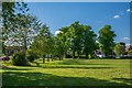
Western Park, Ashby-de-la-Zouch
The West boundary of the park, with Packington Nook Lane (a residential road as far as Willesley Primary School) visible on the left. The lime trees in the distance are part of a historic avenue, starting at Willesley Woods. This avenue has been partially segmented by new roads and development, but still remains generally intact.
Image: © Oliver Mills
Taken: 15 May 2020
0.06 miles
7

Lime trees in Western Park, Ashby-de-la-Zouch
A remnant of the avenue to the Willesley estate. New houses have appeared behind those on Park Close, on the site of the Tamworth Road garage/carwash.
Image: © Oliver Mills
Taken: 13 Jan 2022
0.06 miles
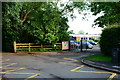
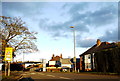
9
Ridgway Road and Tamworth Road junction
In the north west Leicestershire town of Ashby de la Zouch.
Image: © Mat Fascione
Taken: 26 Apr 2008
0.08 miles
10
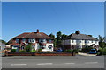
House on Tamworth Rd
This house is on the very northern edge of the grid square. The petrol station is in SK3516
Image: © Nigel Mykura
Taken: 7 Nov 2015
0.08 miles