IMAGES TAKEN NEAR TO
Smedley Close, ASHBY-DE-LA-ZOUCH, LE65 2PN
Introduction
This page details the photographs taken nearby to Smedley Close, LE65 2PN by members of the Geograph project.
The Geograph project started in 2005 with the aim of publishing, organising and preserving representative images for every square kilometre of Great Britain, Ireland and the Isle of Man.

There are currently over 7.5m images from over14,400 individuals and you can help contribute to the project by visiting https://www.geograph.org.uk
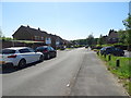
Image Map (Loading...)


Getting Data...Please wait
Leaflet Map data © OpenStreetMap
Images are licensed for reuse under creativecommons.org/licenses/by-sa/2.0
Notes
- Clicking on the map will re-center to the selected point.
- The higher the marker number, the further away the image location is from the centre of the postcode.
Image Listing (16 Images Found)
Images are licensed for reuse under creativecommons.org/licenses/by-sa/2.0
Image
Details
Distance
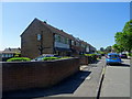
2
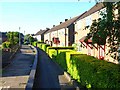
Houses at Ashby-de-la-Zouch
On a walkway which links Ridgway Road and Slaley Avenue
Image: © Oliver Dixon
Taken: 3 Jun 2006
0.06 miles
6
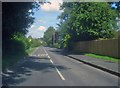
Willesley Road
Looking north-east on the outskirts of Ashby.
Image: © Trevor Rickard
Taken: 22 Aug 2009
0.15 miles
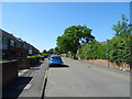
7
Tamworth Road at the junction with Willesley Lane in Ashby-de-le-Zouch
Image: © Peter Robinson
Taken: 17 Apr 2013
0.17 miles
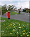
8
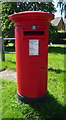
Elizabeth II postbox on Tamworth Road, Ashby-de-la-Zouch
Postbox No. LE65 614.
Image: © JThomas
Taken: 27 Jun 2019
0.18 miles
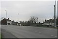
9
Ridgway Road and Tamworth Road junction
In the north west Leicestershire town of Ashby de la Zouch.
Image: © Mat Fascione
Taken: 26 Apr 2008
0.19 miles
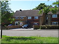
10
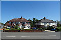
Houses on Tamworth Road, Ashby-de-la-Zouch
Image: © JThomas
Taken: 27 Jun 2019
0.19 miles