IMAGES TAKEN NEAR TO
Donington Drive, ASHBY-DE-LA-ZOUCH, LE65 2NT
Introduction
This page details the photographs taken nearby to Donington Drive, LE65 2NT by members of the Geograph project.
The Geograph project started in 2005 with the aim of publishing, organising and preserving representative images for every square kilometre of Great Britain, Ireland and the Isle of Man.

There are currently over 7.5m images from over14,400 individuals and you can help contribute to the project by visiting https://www.geograph.org.uk
Image Map (Loading...)


Getting Data...Please wait
Leaflet Map data © OpenStreetMap
Images are licensed for reuse under creativecommons.org/licenses/by-sa/2.0
Notes
- Clicking on the map will re-center to the selected point.
- The higher the marker number, the further away the image location is from the centre of the postcode.
Image Listing (32 Images Found)
Images are licensed for reuse under creativecommons.org/licenses/by-sa/2.0
Image
Details
Distance
1
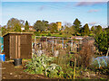
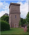
Allotments, Ashby-de-la-Zouch
Showing the Water Tower and the Cemetery grounds at the top of the slope.
Image: © Oliver Mills
Taken: 31 Dec 2021
0.09 miles
3
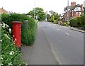
Postbox along Moira Road in Ashby de la Zouch
Image: © Mat Fascione
Taken: 18 May 2008
0.14 miles
4
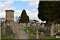
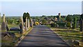
Ashby cemetery and water tower
The cemetery in Ashby, near the allotments. The water tower, now unused, can be seen to the left.
Image: © Oliver Mills
Taken: 11 Apr 2015
0.16 miles
6
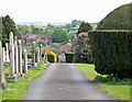
Ashby de la Zouch Cemetery
Located along Moira Road.
Image: © Mat Fascione
Taken: 18 May 2008
0.16 miles
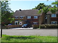
8
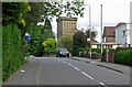
Moira Road in Ashby de la Zouch, Leicestershire
Image: © Mat Fascione
Taken: 18 May 2008
0.17 miles
9
Ashby-de-la-Zouch Cemetery
Located at the top of Kilwardby Hill, near the converted water tower. Views to Birmingham Centre can be received in conditions of good visibility. The town's allotments are located directly at the bottom of the hill.
Image: © Oliver Mills
Taken: 26 May 2020
0.17 miles
10
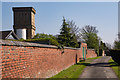
Ashby Cemetery path and Water Tower
Showing the path running along the northern perimeter of the cemetery. The water tower is in the background, and has recently been converted into a modern residence.
Image: © Oliver Mills
Taken: 9 Apr 2017
0.17 miles