IMAGES TAKEN NEAR TO
Rockleigh Gardens, ASHBY-DE-LA-ZOUCH, LE65 2JY
Introduction
This page details the photographs taken nearby to Rockleigh Gardens, LE65 2JY by members of the Geograph project.
The Geograph project started in 2005 with the aim of publishing, organising and preserving representative images for every square kilometre of Great Britain, Ireland and the Isle of Man.

There are currently over 7.5m images from over14,400 individuals and you can help contribute to the project by visiting https://www.geograph.org.uk
Image Map (Loading...)


Getting Data...Please wait
Leaflet Map data © OpenStreetMap
Images are licensed for reuse under creativecommons.org/licenses/by-sa/2.0
Notes
- Clicking on the map will re-center to the selected point.
- The higher the marker number, the further away the image location is from the centre of the postcode.
Image Listing (312 Images Found)
Images are licensed for reuse under creativecommons.org/licenses/by-sa/2.0
Image
Details
Distance
1
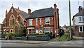
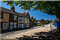
The Methodist Church and the Dalmatian house, Ashby-de-la-Zouch
Burton Road
Image: © Oliver Mills
Taken: 17 Jan 2021
0.04 miles
2
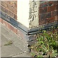
Bench mark, 2, Burton Road Ashby-de-la-Zouch
See http://www.geograph.org.uk/photo/5874470 for location.
Image: © Alan Murray-Rust
Taken: 5 Aug 2018
0.04 miles
3
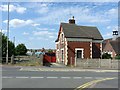
Victorian cottage on Burton Road, Ashby-de-la-Zouch
There's very little to show the origin of this cottage, but the gate into the little field is the nearest to a give-away.
This was the crossing keeper's cottage for a level crossing on the Ashby to Melbourne and Derby railway line which closed to passengers in 1930, and freight in 1980. The V-shape of the field is due to there being a junction here to sidings which themselves followed the line of the original horse-drawn Ticknall Tramway. The sidings served the towns gasworks, with a large gasometer at the end of the field where the blue shed can be seen. Until 1927, the Burton and Ashby tram ran along the main road here.
There is a bench mark http://www.geograph.org.uk/photo/5874466 on the corner of the cottage.
Image: © Alan Murray-Rust
Taken: 5 Aug 2018
0.05 miles
4
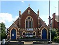
Methodist Church, Burton Road, Ashby-de-la-Zouch
Brick with finely detailed buff terracotta dressings, dated 1906 http://www.geograph.org.uk/photo/5874462
Image: © Alan Murray-Rust
Taken: 5 Aug 2018
0.05 miles
5
Burton Road, Ashby
Straight ahead is Ashby Methodist Church, and on the right behind the blue railings is the Church of England Primary School. Just beyond the brick building on the far right is a drive which previously gave access to Holywell mill - that has now disappeared.
Image: © Oliver Mills
Taken: 26 Jun 2018
0.06 miles
6
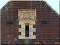
Methodist Church, Burton Road, Ashby-de-la-Zouch ? datestone
See http://www.geograph.org.uk/photo/5874461 for location and information.
Image: © Alan Murray-Rust
Taken: 5 Aug 2018
0.06 miles
7
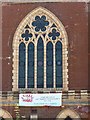
Methodist Church, Burton Road, Ashby-de-la-Zouch ? the main window
A fine example of terracotta tracery in Early English Geometric style. See http://www.geograph.org.uk/photo/5874461 for location and information.
Image: © Alan Murray-Rust
Taken: 5 Aug 2018
0.06 miles
8
Entering Ashby-de-la-Zouch on Burton Road, 1962
View east, past the Ashby Primary School, on what was the A50 trunk road from Burton-on-Trent until about 1990, when new roads and by-passes round Ashby and Coalville were built.
Image: © Ben Brooksbank
Taken: 4 Jun 1962
0.07 miles
9
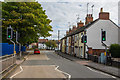
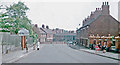
Burton Road, Ashby De La Zouch
Looking towards the roundabout which connects Derby Road and Elford Street (turning into North Street). The C of E primary school is on the left, and the Methodist church on the right.
This picture can be compared with another picture taken in 1962, which can be seen here Image As is the case with many places, things generally look less idyllic today than it did 50 years ago.
Image: © Oliver Mills
Taken: 8 Oct 2017
0.07 miles
10
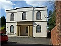
Congregational Church, Ashby-de-la-Zouch
Built 1825, probably replacing an earlier chapel. A sign over the entrance to the courtyard has the date 1662. Listed Grade II.
Image: © Alan Murray-Rust
Taken: 5 Aug 2018
0.07 miles