IMAGES TAKEN NEAR TO
Cedar Court, LEICESTER, LE6 0ET
Introduction
This page details the photographs taken nearby to Cedar Court, LE6 0ET by members of the Geograph project.
The Geograph project started in 2005 with the aim of publishing, organising and preserving representative images for every square kilometre of Great Britain, Ireland and the Isle of Man.

There are currently over 7.5m images from over14,400 individuals and you can help contribute to the project by visiting https://www.geograph.org.uk
Image Map
Images are licensed for reuse under creativecommons.org/licenses/by-sa/2.0
Notes
- Clicking on the map will re-center to the selected point.
- The higher the marker number, the further away the image location is from the centre of the postcode.
Image Listing (4 Images Found)
Images are licensed for reuse under creativecommons.org/licenses/by-sa/2.0
Image
Details
Distance
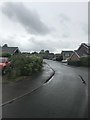
1
Chestnut Walk, Groby
A residential area south of the original village to the west of Leicester.
Image: © Jim Barton
Taken: 14 Sep 2019
0.06 miles
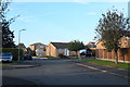
2

Laundon Way's Co-op, Groby
A local supermarket in the residential area.
Image: © Jim Barton
Taken: 14 Sep 2019
0.14 miles
3

Path by recreation field, Groby
A green space in the residential area of Groby.
Image: © Jim Barton
Taken: 14 Sep 2019
0.14 miles