IMAGES TAKEN NEAR TO
Brook Drive, LEICESTER, LE6 0AQ
Introduction
This page details the photographs taken nearby to Brook Drive, LE6 0AQ by members of the Geograph project.
The Geograph project started in 2005 with the aim of publishing, organising and preserving representative images for every square kilometre of Great Britain, Ireland and the Isle of Man.

There are currently over 7.5m images from over14,400 individuals and you can help contribute to the project by visiting https://www.geograph.org.uk
Image Map
Images are licensed for reuse under creativecommons.org/licenses/by-sa/2.0
Notes
- Clicking on the map will re-center to the selected point.
- The higher the marker number, the further away the image location is from the centre of the postcode.
Image Listing (17 Images Found)
Images are licensed for reuse under creativecommons.org/licenses/by-sa/2.0
Image
Details
Distance
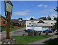
5
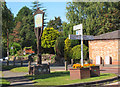
Village sign, Ratby
Sign at the junction of Main Street and Burroughs Road.
Image: © Jim Barton
Taken: 14 Sep 2019
0.16 miles
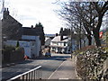
6
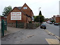
Ratby: southern end of Main Street
The ghost sign of a former dairy business at the farm, which was recently repainted by new owners. This photo http://cdm16445.contentdm.oclc.org/cdm/ref/collection/p15407coll4/id/180 on the University of Leicester website shows the pre-restoration version, dating from a time under different ownership.
Image: © Richard Law
Taken: 28 Jul 2015
0.20 miles
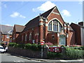
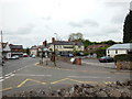
8

The Plough Inn, Ratby
Public House located along Burroughs Road on the western edge of Ratby Village.
Image: © Mat Fascione
Taken: 7 Jul 2007
0.22 miles
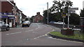
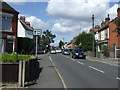
10
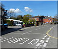
The Main Street in Ratby
At the junction with Berry's Lane, on the left is The Bull's Head public house.
Image: © Mat Fascione
Taken: 15 Apr 2014
0.23 miles