IMAGES TAKEN NEAR TO
Whitehall Road, LEICESTER, LE5 6GJ
Introduction
This page details the photographs taken nearby to Whitehall Road, LE5 6GJ by members of the Geograph project.
The Geograph project started in 2005 with the aim of publishing, organising and preserving representative images for every square kilometre of Great Britain, Ireland and the Isle of Man.

There are currently over 7.5m images from over14,400 individuals and you can help contribute to the project by visiting https://www.geograph.org.uk
Image Map (Loading...)


Getting Data...Please wait
Leaflet Map data © OpenStreetMap
Images are licensed for reuse under creativecommons.org/licenses/by-sa/2.0
Notes
- Clicking on the map will re-center to the selected point.
- The higher the marker number, the further away the image location is from the centre of the postcode.
Image Listing (10 Images Found)
Images are licensed for reuse under creativecommons.org/licenses/by-sa/2.0
Image
Details
Distance
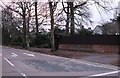
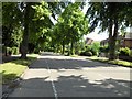
2
Spencefield Lane, Evington, Leicester
The junction with Downing Drive.
Image: © Mat Fascione
Taken: 3 Jun 2007
0.11 miles

5
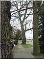
Trees on Goodwood Road, Leicester
Two Oaks frame a mature Willow.
Image: © Michael Trolove
Taken: 24 Mar 2008
0.18 miles
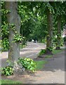
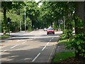
7
Spencefield Lane, Leicester
Leafy lane in the Evington area of Leicester.
Image: © Stephen Sweeney
Taken: 19 Jun 2011
0.21 miles
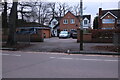
10

Church of God, Evington Meeting Place, Leicester
Image: © Tim Heaton
Taken: 6 Oct 2020
0.24 miles