IMAGES TAKEN NEAR TO
Stoughton Drive North, LEICESTER, LE5 5UD
Introduction
This page details the photographs taken nearby to Stoughton Drive North, LE5 5UD by members of the Geograph project.
The Geograph project started in 2005 with the aim of publishing, organising and preserving representative images for every square kilometre of Great Britain, Ireland and the Isle of Man.

There are currently over 7.5m images from over14,400 individuals and you can help contribute to the project by visiting https://www.geograph.org.uk
Image Map (Loading...)


Getting Data...Please wait
Leaflet Map data © OpenStreetMap
Images are licensed for reuse under creativecommons.org/licenses/by-sa/2.0
Notes
- Clicking on the map will re-center to the selected point.
- The higher the marker number, the further away the image location is from the centre of the postcode.
Image Listing (24 Images Found)
Images are licensed for reuse under creativecommons.org/licenses/by-sa/2.0
Image
Details
Distance
1
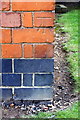
Benchmark on St Philip's Church
Ordnance Survey cut mark benchmark described on the Bench Mark Database at www.bench-marks.org.uk/bm88694
Image: © phil Richards
Taken: 9 Sep 2017
0.06 miles
2
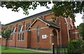
St Philip's Church, NE face
There is an Ordnance Survey benchmark Image on the near corner, left hand face, of the building
Image: © phil Richards
Taken: 9 Sep 2017
0.06 miles

5
Benchmark on No.92 Holmfield Road
Ordnance Survey cut mark benchmark described on the Bench Mark Database at www.bench-marks.org.uk/bm88695
Image: © phil Richards
Taken: 9 Sep 2017
0.09 miles
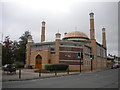
6
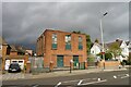
Electricity substation, Evington Road, Leicester
"A good example of a 1930s art deco electricity sub-station. This was one of several sub-stations constructed in the 1930s to serve the inner city and rapidly expanding suburbs, providing an electricity supply as it began to supersede gas as the main means of lighting." (Leicester City Local Heritage Asset Register)
Image: © Tim Heaton
Taken: 6 Oct 2020
0.09 miles
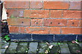
7
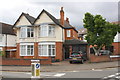
No. 92 Holmfield Road at Stoughton Drive North junction
There is an Ordnance Survey benchmark Image on the right hand side of the house near its front corner on the approach to its front door.
Image: © phil Richards
Taken: 9 Sep 2017
0.09 miles

10
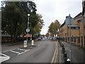
West end of Evington Drive, Evington
Image: © Richard Vince
Taken: 16 Oct 2018
0.10 miles