IMAGES TAKEN NEAR TO
Kingsway Road, LEICESTER, LE5 5TU
Introduction
This page details the photographs taken nearby to Kingsway Road, LE5 5TU by members of the Geograph project.
The Geograph project started in 2005 with the aim of publishing, organising and preserving representative images for every square kilometre of Great Britain, Ireland and the Isle of Man.

There are currently over 7.5m images from over14,400 individuals and you can help contribute to the project by visiting https://www.geograph.org.uk
Image Map (Loading...)


Getting Data...Please wait
Leaflet Map data © OpenStreetMap
Images are licensed for reuse under creativecommons.org/licenses/by-sa/2.0
Notes
- Clicking on the map will re-center to the selected point.
- The higher the marker number, the further away the image location is from the centre of the postcode.
Image Listing (30 Images Found)
Images are licensed for reuse under creativecommons.org/licenses/by-sa/2.0
Image
Details
Distance
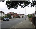
1
Gartree Road, Stoneygate
Looking towards Turnbury Way.
Image: © David Howard
Taken: 5 Mar 2023
0.08 miles
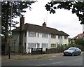
4
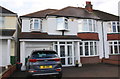
#69 Gartree Road
Ordnance Survey documents indicate that in 1965 a benchmark levelled at 77.255m above Newlyn Datum was verified on a detached garage behind the house. The house has since been extended on its left hand face with an integral garage (blocking access to the rear of the house) and rooms above
Image: © Roger Templeman
Taken: 16 Sep 2017
0.09 miles
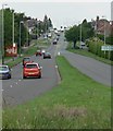
9
Bridge on Highway Road
There is a stream beneath.
Image: © Andrew Tatlow
Taken: 8 Sep 2011
0.14 miles
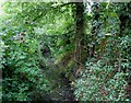
10
Bridge on Highway Road east side
There is a stream beneath.
Image: © Andrew Tatlow
Taken: 8 Sep 2011
0.14 miles