IMAGES TAKEN NEAR TO
LE5 4ZL
Introduction
This page details the photographs taken nearby to LE5 4ZL by members of the Geograph project.
The Geograph project started in 2005 with the aim of publishing, organising and preserving representative images for every square kilometre of Great Britain, Ireland and the Isle of Man.

There are currently over 7.5m images from over14,400 individuals and you can help contribute to the project by visiting https://www.geograph.org.uk
Image Map
Images are licensed for reuse under creativecommons.org/licenses/by-sa/2.0
Notes
- Clicking on the map will re-center to the selected point.
- The higher the marker number, the further away the image location is from the centre of the postcode.
Image Listing (15 Images Found)
Images are licensed for reuse under creativecommons.org/licenses/by-sa/2.0
Image
Details
Distance
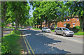
2
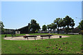
Park and playground between Coleman Road and Leicester Ring Road
The Church of England parish church dedicated to St Chad is in the background.
Image: © Andrew Tatlow
Taken: 6 Jun 2016
0.06 miles
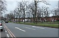
3
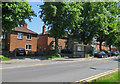
Coleman Road towards Leicester General Hospital
Image: © Andrew Tatlow
Taken: 6 Jun 2016
0.07 miles
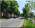
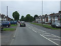
5
Coleman Road towards Leicester Ring Road junction
Image: © Andrew Tatlow
Taken: 6 Jun 2016
0.08 miles
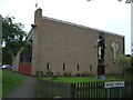
8
Broad Avenue in North Evington, Leicester
Image: © Mat Fascione
Taken: 24 Oct 2017
0.12 miles
9
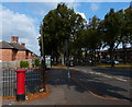
Postbox along Coleman Road in North Evington
The postbox is opposite the junction with the Wayne Way.
Image: © Mat Fascione
Taken: 21 Sep 2014
0.13 miles
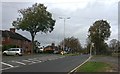
10
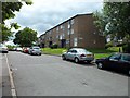
Avonside Drive, Leicester
Residential street just off Coleman Road, located near the General Hospital.
Image: © Stephen Sweeney
Taken: 19 Jun 2011
0.14 miles