IMAGES TAKEN NEAR TO
Wicklow Drive, LEICESTER, LE5 4RB
Introduction
This page details the photographs taken nearby to Wicklow Drive, LE5 4RB by members of the Geograph project.
The Geograph project started in 2005 with the aim of publishing, organising and preserving representative images for every square kilometre of Great Britain, Ireland and the Isle of Man.

There are currently over 7.5m images from over14,400 individuals and you can help contribute to the project by visiting https://www.geograph.org.uk
Image Map
Images are licensed for reuse under creativecommons.org/licenses/by-sa/2.0
Notes
- Clicking on the map will re-center to the selected point.
- The higher the marker number, the further away the image location is from the centre of the postcode.
Image Listing (11 Images Found)
Images are licensed for reuse under creativecommons.org/licenses/by-sa/2.0
Image
Details
Distance
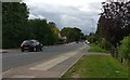
2
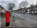
Postbox on Wicklow Drive in Crown Hills, Leicester
Image: © Mat Fascione
Taken: 1 Mar 2024
0.12 miles
5
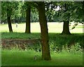
Humberstone Park, Leicester
and squirrel.
Image: © Mat Fascione
Taken: 17 Jun 2007
0.16 miles
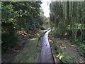
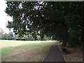
7
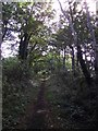
Path along a former railway embankment
The embankment was built by the Great Northern Railway and is now part of Humberstone Park.
Image: © Tim Glover
Taken: 31 Aug 2016
0.18 miles
8

Sculpture
Located in Humberstone Park, Leicester.
Image: © Mat Fascione
Taken: 17 Jun 2007
0.20 miles