IMAGES TAKEN NEAR TO
Gwendolen Road, LEICESTER, LE5 4QF
Introduction
This page details the photographs taken nearby to Gwendolen Road, LE5 4QF by members of the Geograph project.
The Geograph project started in 2005 with the aim of publishing, organising and preserving representative images for every square kilometre of Great Britain, Ireland and the Isle of Man.

There are currently over 7.5m images from over14,400 individuals and you can help contribute to the project by visiting https://www.geograph.org.uk
Image Map
Images are licensed for reuse under creativecommons.org/licenses/by-sa/2.0
Notes
- Clicking on the map will re-center to the selected point.
- The higher the marker number, the further away the image location is from the centre of the postcode.
Image Listing (23 Images Found)
Images are licensed for reuse under creativecommons.org/licenses/by-sa/2.0
Image
Details
Distance
1
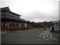
Outpatients entrance, Evington Centre, Leicester General Hospital
Image: © Tim Heaton
Taken: 6 Oct 2020
0.04 miles
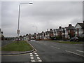
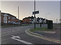
2
Gwendolen Road, Leicester General Hospital
The main road through the hospital campus.
Image: © Richard Vince
Taken: 16 Oct 2018
0.08 miles
3
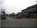
Bus at Leicester General Hospital
First Leicester 66311, a Volvo B7L/Wright Eclipse (several of which were still running in Leicester when I visited, much to my surprise), lays over on the General Hospital campus before returning to the city centre on route 16.
Image: © Richard Vince
Taken: 16 Oct 2018
0.09 miles
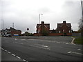
4
Road to Leicester General Hospital entrance
Image: © Richard Vince
Taken: 16 Oct 2018
0.09 miles
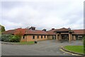
5
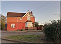
The keeper's cottage at Leicester General Hospital
Image: © David Howard
Taken: 20 Sep 2020
0.10 miles
6
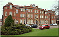
Leicester General Hospital, Evington, Leicester
The front elevation of Hadley Hall, the oldest part of the hospital and the original main entrance. It was the main administrative block of the North Evington Poor Law Infirmary (1905-1930), a hospital that cost of £79,575. It was designed to accommodate 512 patients and was considered ultra-modern and one of the largest and finest infirmaries in England. It was apparently known by the local people as “The Palace on the Hill”. It had 16 strictly segregated wards, each one named after a municipal ward in the city. It was surrounded by 6ft high spiked railings with gates were kept locked requiring visitors to apply for a pass in order to be allowed into the grounds or buildings. Later, the complex became known as Leicester City General Hospital (1930 - c.1948). It is now known as Leicester General Hospital and it hosts the headquarters of University Hospitals of Leicester NHS Trust (UHL). It is three miles east of Leicester city centre and has approximately 680 beds.
Image: © David Hallam-Jones
Taken: 26 Dec 2014
0.10 miles
7
Entrance to Leicester General Infirmary buildings
With restaurant and public catering facilities in centre.
Image: © Chris Morgan
Taken: 9 May 2015
0.10 miles
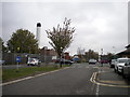
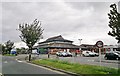
8
Wakerley Road, Leicester
At the entrance to the general hospital
Image: © David Howard
Taken: 20 Sep 2020
0.12 miles
9
Bus turning circle, Wakerley Road, North Evington
Served by First Leicester route 16 as it leaves the Leicester General Hospital campus.
Image: © Richard Vince
Taken: 16 Oct 2018
0.12 miles