IMAGES TAKEN NEAR TO
Deepdale, LEICESTER, LE5 4LS
Introduction
This page details the photographs taken nearby to Deepdale, LE5 4LS by members of the Geograph project.
The Geograph project started in 2005 with the aim of publishing, organising and preserving representative images for every square kilometre of Great Britain, Ireland and the Isle of Man.

There are currently over 7.5m images from over14,400 individuals and you can help contribute to the project by visiting https://www.geograph.org.uk
Image Map
Images are licensed for reuse under creativecommons.org/licenses/by-sa/2.0
Notes
- Clicking on the map will re-center to the selected point.
- The higher the marker number, the further away the image location is from the centre of the postcode.
Image Listing (18 Images Found)
Images are licensed for reuse under creativecommons.org/licenses/by-sa/2.0
Image
Details
Distance
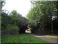
1
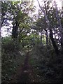
Path along a former railway embankment
The embankment was built by the Great Northern Railway and is now part of Humberstone Park.
Image: © Tim Glover
Taken: 31 Aug 2016
0.10 miles
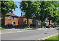
2
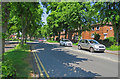
Coleman Road towards Leicester Ring Road junction
Image: © Andrew Tatlow
Taken: 6 Jun 2016
0.15 miles
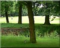
4
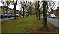
Trees in the centre of Coleman Road
In the North Evington area of Leicester.
Image: © Mat Fascione
Taken: 24 Oct 2017
0.17 miles
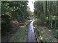
7
Humberstone Park, Leicester
and squirrel.
Image: © Mat Fascione
Taken: 17 Jun 2007
0.19 miles
8
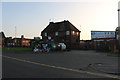
The Blu Ivy pub on Coleman Road, North Evington
It has just reopened after being The Triangle. Here are the property details. https://www.primelocation.com/to-rent/details/55462664
Image: © David Howard
Taken: 20 Sep 2020
0.19 miles
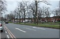
10
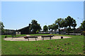
Park and playground between Coleman Road and Leicester Ring Road
The Church of England parish church dedicated to St Chad is in the background.
Image: © Andrew Tatlow
Taken: 6 Jun 2016
0.19 miles