IMAGES TAKEN NEAR TO
Kinsdale Drive, LEICESTER, LE5 2PW
Introduction
This page details the photographs taken nearby to Kinsdale Drive, LE5 2PW by members of the Geograph project.
The Geograph project started in 2005 with the aim of publishing, organising and preserving representative images for every square kilometre of Great Britain, Ireland and the Isle of Man.

There are currently over 7.5m images from over14,400 individuals and you can help contribute to the project by visiting https://www.geograph.org.uk
Image Map
Images are licensed for reuse under creativecommons.org/licenses/by-sa/2.0
Notes
- Clicking on the map will re-center to the selected point.
- The higher the marker number, the further away the image location is from the centre of the postcode.
Image Listing (14 Images Found)
Images are licensed for reuse under creativecommons.org/licenses/by-sa/2.0
Image
Details
Distance
1
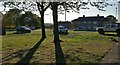
Small green space on Bowhill Grove
In the Thurnby Lodge area of Leicester.
Image: © Mat Fascione
Taken: 4 Oct 2018
0.17 miles
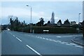
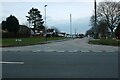
3
Station Lane, Scraptoft
At the junction of Rose Acre Close
Image: © David Howard
Taken: 5 Mar 2023
0.19 miles
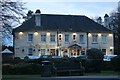
4

The White House in Scraptoft
A Wetherspoon public house along Scraptoft Lane.
Image: © Mat Fascione
Taken: 9 Dec 2012
0.21 miles
5
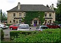
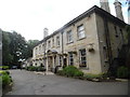
The White House, Scraptoft
Located along Scraptoft Lane east of Leicester. It was originally built in Normanton near Rutland Water in 1926 but was removed brick by brick and re-built in 1931. It is now a public house.
Image: © Mat Fascione
Taken: 17 Jun 2007
0.21 miles
7
The White House, Scraptoft
A Wetherspoons pub in the Leicestershire village.
Image: © Stephen Sweeney
Taken: 2 Jul 2016
0.22 miles

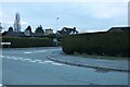
10
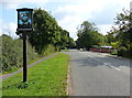
Scraptoft village sign along Scraptoft Lane
Image: © Mat Fascione
Taken: 21 Sep 2014
0.23 miles