IMAGES TAKEN NEAR TO
Drumcliff Road, LEICESTER, LE5 2LH
Introduction
This page details the photographs taken nearby to Drumcliff Road, LE5 2LH by members of the Geograph project.
The Geograph project started in 2005 with the aim of publishing, organising and preserving representative images for every square kilometre of Great Britain, Ireland and the Isle of Man.

There are currently over 7.5m images from over14,400 individuals and you can help contribute to the project by visiting https://www.geograph.org.uk
Image Map
Images are licensed for reuse under creativecommons.org/licenses/by-sa/2.0
Notes
- Clicking on the map will re-center to the selected point.
- The higher the marker number, the further away the image location is from the centre of the postcode.
Image Listing (11 Images Found)
Images are licensed for reuse under creativecommons.org/licenses/by-sa/2.0
Image
Details
Distance
1
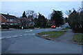
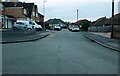
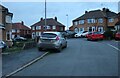
Station Road, Thurnby
At the end of Somerby Road
Image: © David Howard
Taken: 5 Mar 2023
0.09 miles
6
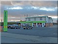
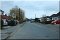
The co-operative store along Station Road
The former Swallow Inn public house.
Image: © Mat Fascione
Taken: 9 Dec 2012
0.23 miles
7
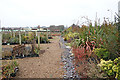
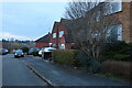
James Coles Plant Nursery, Thurnby, Leicester
On the main A47 at the corner of Uppingham Road and Station Road, this large commercial nursery and garden centre occupies a large proportion of this square. The building with the green roof, centre left, is the Swallow public house.
Image: © Kate Jewell
Taken: 5 Jan 2006
0.23 miles
8
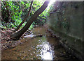
Bushby Brook downstream
The massive wall to the right is presumably a flood defence for the houses on the other side. The foundations look a bit rough and one wonders whether the brook is gradually undercutting them. This stretch of Bushby Brook seems a forgotten and neglected place!
Image: © Andrew Tatlow
Taken: 27 Jun 2016
0.25 miles
9
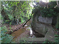
Bushby Brook downstream
The structure in the foreground is where pipes from the adjacent flood relief basin drain to the brook.The massive wall to the right acts as a flood defence for the houses on the other side. Its foundations look a bit rough and one wonders whether the brook is gradually undercutting them.This stretch of Bushby Brook seems a forgotten and neglected place!
Image: © Andrew Tatlow
Taken: 27 Jun 2016
0.25 miles
10
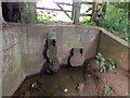
Drainage pipes from flood relief basin into Bushby Brook
The flaps on the pipe ends act as valves to prevent water from the brook backing up into the adjacent flood relief basin. It was not clear whether there were 2 pipes from the flood relief basin or whether one of them was from elsewhere.
Image: © Andrew Tatlow
Taken: 27 Jun 2016
0.25 miles