IMAGES TAKEN NEAR TO
Thurmaston Boulevard, LEICESTER, LE4 9HS
Introduction
This page details the photographs taken nearby to Thurmaston Boulevard, LE4 9HS by members of the Geograph project.
The Geograph project started in 2005 with the aim of publishing, organising and preserving representative images for every square kilometre of Great Britain, Ireland and the Isle of Man.

There are currently over 7.5m images from over14,400 individuals and you can help contribute to the project by visiting https://www.geograph.org.uk
Image Map (Loading...)


Getting Data...Please wait
Leaflet Map data © OpenStreetMap
Images are licensed for reuse under creativecommons.org/licenses/by-sa/2.0
Notes
- Clicking on the map will re-center to the selected point.
- The higher the marker number, the further away the image location is from the centre of the postcode.
Image Listing (18 Images Found)
Images are licensed for reuse under creativecommons.org/licenses/by-sa/2.0
Image
Details
Distance
1
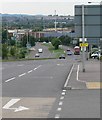
Thurmaston Lane, Leicester
This forms part of the A563 outer ring road.
Image: © Mat Fascione
Taken: 16 Jul 2007
0.04 miles
2

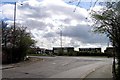
Thurmaston Lane (A563)
Industrial estates feature on both sides of the road.
Image: © Peter Whatley
Taken: 28 Jul 2013
0.05 miles
4

Thurmaston Lane, Leicester
Part of Leicester's outer ring road.
Image: © Mat Fascione
Taken: 16 Jul 2007
0.11 miles


7
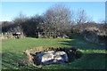
The Humber Stone - Glacial Erratic
The Humber stone is a Syenite glacial erratic brought here by ice between 478,000 and 424,000 years ago during the Anglian stage glaciation. Its original location was the Mountsorrel intrusions a few miles north, you can see the chimney of the quarry works from this site.
The syenite is a granitic rock, formed when the Tornquist sea closed not long before the Caledonian Orogeny during the Ordovician/Silurian. A subduction zone was sited under the north sea with Avalonia being subducted and later colliding with Baltica. This produced a line of volcanic intrusions deep down running from the Lake District right down to here and even East Anglia. There is magnetic evidence for a pluton underneath the Wash.
It is sited next to a roundabout on the Leicester outer ring road, it is signed and has an information board.
Image: © Ashley Dace
Taken: 20 Jan 2011
0.18 miles

9

Taylor Hobson sign
Taylor Hobson was once a major supplier of lenses to the British camera industry; the lens business was taken over by Cooke Optics Ltd in Leicester. Taylor Hobson is now part of AMETEK's Ultra Precision Technologies Group and according to their website "a world leader in the design, development and supply of precision metrology equipment".
Image: © Andrew Tatlow
Taken: 18 Apr 2013
0.19 miles
10
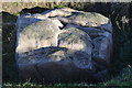
The Humber Stone - Glacial Erratic
The Humber stone is a Syenite glacial erratic brought here by ice between 478,000 and 424,000 years ago during the Anglian stage glaciation. Its original location was the Mountsorrel intrusions a few miles north, you can see the chimney of the quarry works from this site.
The syenite is a granitic rock, formed when the Tornquist sea closed not long before the Caledonian Orogeny during the Ordovician/Silurian. A subduction zone was sited under the north sea with Avalonia being subducted and later colliding with Baltica. This produced a line of volcanic intrusions deep down running from the Lake District right down to here and even East Anglia. There is magnetic evidence for a pluton underneath the Wash.
It is sited next to a roundabout on the Leicester outer ring road, it is signed and has an information board.
Image: © Ashley Dace
Taken: 20 Jan 2011
0.19 miles