IMAGES TAKEN NEAR TO
Wayside Drive, LEICESTER, LE4 8JX
Introduction
This page details the photographs taken nearby to Wayside Drive, LE4 8JX by members of the Geograph project.
The Geograph project started in 2005 with the aim of publishing, organising and preserving representative images for every square kilometre of Great Britain, Ireland and the Isle of Man.

There are currently over 7.5m images from over14,400 individuals and you can help contribute to the project by visiting https://www.geograph.org.uk
Image Map (Loading...)


Getting Data...Please wait
Leaflet Map data © OpenStreetMap
Images are licensed for reuse under creativecommons.org/licenses/by-sa/2.0
Notes
- Clicking on the map will re-center to the selected point.
- The higher the marker number, the further away the image location is from the centre of the postcode.
Image Listing (38 Images Found)
Images are licensed for reuse under creativecommons.org/licenses/by-sa/2.0
Image
Details
Distance
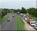
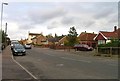
1

Newark Road
The police van was sounding sirens and flashing blue lights.
Image: © Andrew Tatlow
Taken: 12 Oct 2011
0.09 miles
5
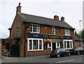
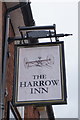
The Harrow Inn
Public House on Melton Road in Thurmaston.
Image: © Mat Fascione
Taken: 16 Jul 2007
0.14 miles
6
The Harrow Inn
On Melton Road, Thurmaston. http://www.geograph.org.uk/photo/4967348
Image: © Ian S
Taken: 25 May 2016
0.14 miles
7
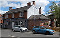
The Harrow Inn at Thurmaston
Public House on Melton Road.
Image: © Mat Fascione
Taken: 2 May 2020
0.14 miles
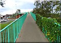
10
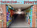
Thurmaston Subway
Thurmaston Subway runs under the A607. It was repainted for the jubilee in 2022.
Image: © Ian Calderwood
Taken: 18 Jul 2024
0.14 miles