IMAGES TAKEN NEAR TO
Campbell Avenue, LEICESTER, LE4 8HB
Introduction
This page details the photographs taken nearby to Campbell Avenue, LE4 8HB by members of the Geograph project.
The Geograph project started in 2005 with the aim of publishing, organising and preserving representative images for every square kilometre of Great Britain, Ireland and the Isle of Man.

There are currently over 7.5m images from over14,400 individuals and you can help contribute to the project by visiting https://www.geograph.org.uk
Image Map
Images are licensed for reuse under creativecommons.org/licenses/by-sa/2.0
Notes
- Clicking on the map will re-center to the selected point.
- The higher the marker number, the further away the image location is from the centre of the postcode.
Image Listing (12 Images Found)
Images are licensed for reuse under creativecommons.org/licenses/by-sa/2.0
Image
Details
Distance

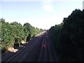
2
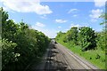
The Midland Main Line entering Leicester through Thurmaston
Image: © Tim Heaton
Taken: 10 May 2022
0.12 miles
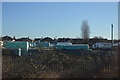
5
Midland main line railway from Humberstone Lane bridge
The bridge is numbered SPC5/25
Image: © Tim Glover
Taken: 30 Aug 2016
0.16 miles
6
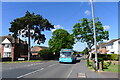
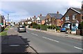
Arriva service #6 on Humberstone Lane, Leicester
A half-hourly bus serving Thurmaston
Image: © Tim Heaton
Taken: 10 May 2022
0.17 miles
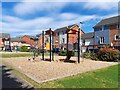
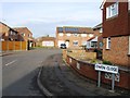
8
Silverdale Drive, Thurmaston, Leicester
This area is called the Dales because all the roads names end in "dale', Parkdale, Dovedale, Ivydale for example.
Image: © Kate Jewell
Taken: 31 Oct 2005
0.17 miles
9
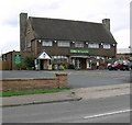
The Willow
Public House on Humberstone Lane in Thurmaston, Leicester.
Image: © Mat Fascione
Taken: 16 Jul 2007
0.20 miles