IMAGES TAKEN NEAR TO
Windmill Close, LEICESTER, LE4 8GX
Introduction
This page details the photographs taken nearby to Windmill Close, LE4 8GX by members of the Geograph project.
The Geograph project started in 2005 with the aim of publishing, organising and preserving representative images for every square kilometre of Great Britain, Ireland and the Isle of Man.

There are currently over 7.5m images from over14,400 individuals and you can help contribute to the project by visiting https://www.geograph.org.uk
Image Map
Images are licensed for reuse under creativecommons.org/licenses/by-sa/2.0
Notes
- Clicking on the map will re-center to the selected point.
- The higher the marker number, the further away the image location is from the centre of the postcode.
Image Listing (17 Images Found)
Images are licensed for reuse under creativecommons.org/licenses/by-sa/2.0
Image
Details
Distance
3
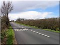
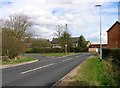
Highway Road, Thurmaston
Arriva Midlands bus on Route 6 to Leicester Haymarket
Image: © Tim Heaton
Taken: 1 Feb 2021
0.12 miles
4
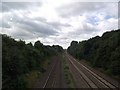
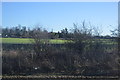
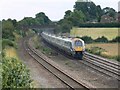
Midland main line railway south of Barkby Thorpe Lane
222001 is in the distance with a southbound train
Image: © Tim Glover
Taken: 3 Aug 2016
0.13 miles
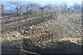
8
Another view of the railway
Looking south towards Barkby Thorpe Lane railway bridge. Photographed from Barkby Lane railway bridge.
Image: © Mat Fascione
Taken: 16 Jul 2007
0.18 miles
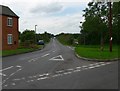
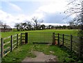
9
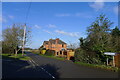
Junction of Duck Pond Lane and Barkby Thorpe Lane
Image: © Tim Heaton
Taken: 1 Feb 2021
0.19 miles