IMAGES TAKEN NEAR TO
Earls Close, Earls Close Industrial Estate, LEICESTER, LE4 8FZ
Introduction
This page details the photographs taken nearby to Earls Close, Earls Close Industrial Estate, LE4 8FZ by members of the Geograph project.
The Geograph project started in 2005 with the aim of publishing, organising and preserving representative images for every square kilometre of Great Britain, Ireland and the Isle of Man.

There are currently over 7.5m images from over14,400 individuals and you can help contribute to the project by visiting https://www.geograph.org.uk
Image Map (Loading...)


Getting Data...Please wait
Leaflet Map data © OpenStreetMap
Images are licensed for reuse under creativecommons.org/licenses/by-sa/2.0
Notes
- Clicking on the map will re-center to the selected point.
- The higher the marker number, the further away the image location is from the centre of the postcode.
Image Listing (12 Images Found)
Images are licensed for reuse under creativecommons.org/licenses/by-sa/2.0
Image
Details
Distance
1
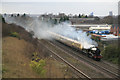
Thurmaston - steam special on the main line
GWR 'Hall' class Rood Ashton Hall hauling a special to Melton Mowbray for the Xmas market. Photographed from an over bridge carrying a public footpath. Apart from the four of us there were no other gricers. The view is reasonable and uphill but the driver throttled back a bit just before reaching this point and the curse of the railway photographer - drifting steam and smoke - is in evidence. This was a quick break from photographing old mills and a later trip to the Abbey Pumping Station for the beam engines in steam.
Image: © Chris Allen
Taken: 4 Dec 2011
0.11 miles
2
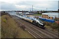
Rood Ashton Hall 4965
A view of the railtour to Melton Mowbray from a small footbridge at Thurmaston, around 5 down (5 minutes late).
Image: © Ashley Dace
Taken: 4 Dec 2011
0.13 miles
4

Rood Ashton Hall 4965
A view of the railtour to Melton Mowbray from a small footbridge at Thurmaston, around 5 down.
Image]
Image: © Ashley Dace
Taken: 4 Dec 2011
0.16 miles
7
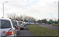
Traffic jam on the Thurmaston By-pass
Stuck in the traffic at 9.00 am! Roadworks at the Humberstone Lane junction caused this tail back to the Image
Image: © Kate Jewell
Taken: 6 Mar 2006
0.19 miles
8
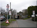
Railway bridge over Church Hill Road, Thurmaston
A very low (9'6") bridge carrying the Midland Main Line north of Leicester over Church Hill Road. Although the flood of which the sign on the left warns was no longer present, the carriageway was still looking quite wet, so presumably it was a fairly recent event.
Image: © Richard Vince
Taken: 11 Mar 2017
0.21 miles
10
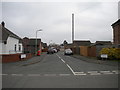
Dickinson Way, Thurmaston
A residential cul de sac off Church Hill Road.
Image: © Richard Vince
Taken: 11 Mar 2017
0.22 miles