IMAGES TAKEN NEAR TO
Melton Road, LEICESTER, LE4 8BT
Introduction
This page details the photographs taken nearby to Melton Road, LE4 8BT by members of the Geograph project.
The Geograph project started in 2005 with the aim of publishing, organising and preserving representative images for every square kilometre of Great Britain, Ireland and the Isle of Man.

There are currently over 7.5m images from over14,400 individuals and you can help contribute to the project by visiting https://www.geograph.org.uk
Image Map
Images are licensed for reuse under creativecommons.org/licenses/by-sa/2.0
Notes
- Clicking on the map will re-center to the selected point.
- The higher the marker number, the further away the image location is from the centre of the postcode.
Image Listing (63 Images Found)
Images are licensed for reuse under creativecommons.org/licenses/by-sa/2.0
Image
Details
Distance
1

Under construction
A new Costco superstore in Thurmaston.
Image: © Mat Fascione
Taken: 10 Nov 2012
0.07 miles

3
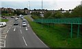
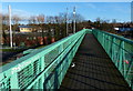
Footbridge across the A607
Looking back towards Melton Road and Thurmaston.
Image: © Mat Fascione
Taken: 16 Jul 2007
0.10 miles
4

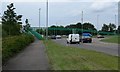
Roundabout, Thurmaston
This is where you hit the outskirts of Leicester as you approach the city from Nottingham and the A46
Image: © Kate Jewell
Taken: 16 Aug 2005
0.12 miles
5
Footbridge
Across the A607 north of Thurmaston.
Image: © Mat Fascione
Taken: 16 Jul 2007
0.13 miles
6
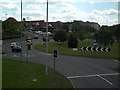
Thurmaston Roundabout
Taken from the footbridge.
Entering the Thurmaston Shopping Centre from the roundabout towards Barkby Thorpe.
Image: © Jon Matthews Driving School
Taken: Unknown
0.13 miles
7
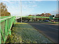
Footbridge over the A607
A significant footbridge which allows pedestrians and cyclists to cross the busy A607 dual carriageway. The photo is taken from a point at the foot of the ramp in Image
Image: © Richard Law
Taken: 8 Nov 2016
0.13 miles
9
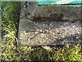
OS rivet - Thurmaston, footbridge support
An OS rivet and arrow mark on one of the concrete footings to the bridge over the A607; originally levelled in 1985 at 57.991m above Ordnance Datum Newlyn.
Image: © Richard Law
Taken: 8 Nov 2016
0.14 miles
10
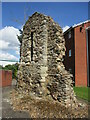
Remains of the chapel of St. John the Evangelist, Thurmaston
Probably dates from the thirteenth century https://historicengland.org.uk/listing/the-list/list-entry/1074472?section=official-list-entry
Image: © Jonathan Thacker
Taken: 8 Apr 2022
0.14 miles