IMAGES TAKEN NEAR TO
Maple Road, LEICESTER, LE4 8AJ
Introduction
This page details the photographs taken nearby to Maple Road, LE4 8AJ by members of the Geograph project.
The Geograph project started in 2005 with the aim of publishing, organising and preserving representative images for every square kilometre of Great Britain, Ireland and the Isle of Man.

There are currently over 7.5m images from over14,400 individuals and you can help contribute to the project by visiting https://www.geograph.org.uk
Image Map
Images are licensed for reuse under creativecommons.org/licenses/by-sa/2.0
Notes
- Clicking on the map will re-center to the selected point.
- The higher the marker number, the further away the image location is from the centre of the postcode.
Image Listing (35 Images Found)
Images are licensed for reuse under creativecommons.org/licenses/by-sa/2.0
Image
Details
Distance
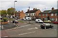
2
Shops at Humberstone Lane/Melton Road junction
Image: © Andrew Tatlow
Taken: 12 Oct 2011
0.07 miles
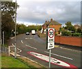
7
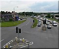
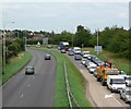
Melton Road, Thurmaston
The busy junction of Melton road, Newark Road and Humberstone Lane. Photographed looking southwest from the footbridge.
Image: © Mat Fascione
Taken: 16 Jul 2007
0.11 miles
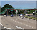
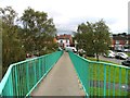
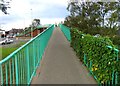
8
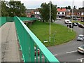
Footbridge
Across the busy Newark road in Thurmaston.
Image: © Mat Fascione
Taken: 16 Jul 2007
0.11 miles