IMAGES TAKEN NEAR TO
Wesley Street, LEICESTER, LE4 5QG
Introduction
This page details the photographs taken nearby to Wesley Street, LE4 5QG by members of the Geograph project.
The Geograph project started in 2005 with the aim of publishing, organising and preserving representative images for every square kilometre of Great Britain, Ireland and the Isle of Man.

There are currently over 7.5m images from over14,400 individuals and you can help contribute to the project by visiting https://www.geograph.org.uk
Image Map
Images are licensed for reuse under creativecommons.org/licenses/by-sa/2.0
Notes
- Clicking on the map will re-center to the selected point.
- The higher the marker number, the further away the image location is from the centre of the postcode.
Image Listing (107 Images Found)
Images are licensed for reuse under creativecommons.org/licenses/by-sa/2.0
Image
Details
Distance
1
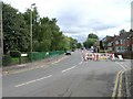
Roadworks on Thurcaston Road, Leicester
Just off to the left of the picture is Belgrave St. Peter's C of E Primary School, evidenced by the yellow zig-zag road markings. It must be chaos at picking up time with these roadworks in place.
Image: © David P Howard
Taken: 14 Sep 2010
0.01 miles
3
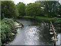
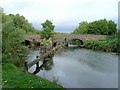
River Soar from Thurcaston Road footbridge
Looking south along the River Soar which is navigable at this point and forms part of the Grand Union Canal. Thurcaston Road crosses the river by a separate bridge to the footpath, which crosses alongside.Image
Image: © David P Howard
Taken: 14 Sep 2010
0.07 miles
4
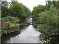
River Soar from Thurcaston Road footbridge
Looking south along the River Soar which is navigable at this point on the other side of the barrier and forms part of the Grand Union Canal. Thurcaston Road crosses the river by a separate bridge to the footpath, which crosses alongside. Image
Image: © David P Howard
Taken: 14 Sep 2010
0.07 miles
5
Thurcaston Road bridges over River Soar
Looking north along the River Soar which is navigable at this point on the right side of the barrier and forms part of the Grand Union Canal. Thurcaston Road crosses the river by a separate bridge to the footpath, which crosses alongside.
Image: © David P Howard
Taken: 14 Sep 2010
0.07 miles
6
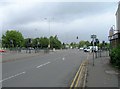
Junction of A6 Abbey Lane and Thurcaston Road
Looking NNE up Abbey Lane towards the junction with Thurcaston Road.
Image: © David P Howard
Taken: 14 Sep 2010
0.09 miles
7
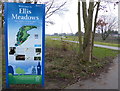
Welcome to Ellis Meadows
Ellis Meadows is a 20-acre park and nature reserve that has been created within the grounds of the former John Ellis School, in Belgrave.
The project has been carried out by the Environment Agency, in partnership with Leicester City Council, as part of a wider scheme to reduce the risk of flooding from the nearby River Soar.
Image: © Mat Fascione
Taken: 5 Feb 2017
0.09 miles
8
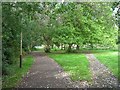
Riverside walk along the Soar
Looking NE up the footpath which follows alongside the River Soar. The river is navigable at this point and forms part of the Grand Union Canal.
Image: © David P Howard
Taken: 14 Sep 2010
0.09 miles
9
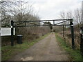
Entrance to Red Circle Angling Club and Nature Reserve
Image: © Jonathan Thacker
Taken: 2 Mar 2023
0.10 miles
10
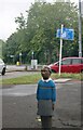
Indian girl statue on Abbey Lane, Belgrave
Image: © David Howard
Taken: 5 Jun 2022
0.10 miles