IMAGES TAKEN NEAR TO
Myrtle Avenue, LEICESTER, LE4 4HS
Introduction
This page details the photographs taken nearby to Myrtle Avenue, LE4 4HS by members of the Geograph project.
The Geograph project started in 2005 with the aim of publishing, organising and preserving representative images for every square kilometre of Great Britain, Ireland and the Isle of Man.

There are currently over 7.5m images from over14,400 individuals and you can help contribute to the project by visiting https://www.geograph.org.uk
Image Map
Images are licensed for reuse under creativecommons.org/licenses/by-sa/2.0
Notes
- Clicking on the map will re-center to the selected point.
- The higher the marker number, the further away the image location is from the centre of the postcode.
Image Listing (11 Images Found)
Images are licensed for reuse under creativecommons.org/licenses/by-sa/2.0
Image
Details
Distance
1
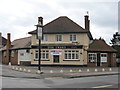
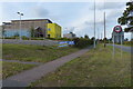
Birstall Trees Pub
Pub in residential area on Stonehill Avenue.
Image: © the bitterman
Taken: 27 Mar 2010
0.16 miles
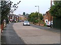
2
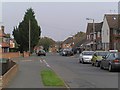
Windmill Avenue towards junction of Wanlip Lane
Image: © Wesley Trevor Johnston
Taken: 11 Oct 2007
0.16 miles
3
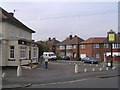
The Trees Public House
The name derives from the surrounding residential streets which are named Sycamore,Hazel,Rosetree,Maple,Myrtle,etc.
Image: © Wesley Trevor Johnston
Taken: 11 Oct 2007
0.17 miles
4
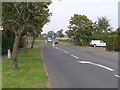
The entrance to Birstall on Wanlip Lane
The tower of the Church at the village of Wanlip can just be made out through the trees in the centre of the photo.
Image: © Wesley Trevor Johnston
Taken: 11 Oct 2007
0.17 miles
5
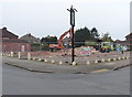
Demolition of the Trees public house
A view of the pub from four years earlier, Image
Image: © Mat Fascione
Taken: 3 Apr 2014
0.18 miles
6
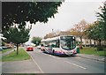
Bus on Wanlip Lane, Birstall
First Leicester 66320, a Volvo B7L/Wright Eclipse, lays over at the terminus of route 70 from Blackmore Drive via Leicester city centre.
Image: © Richard Vince
Taken: 13 Oct 2007
0.18 miles
8
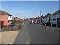
Stonehill Avenue, Birstall
Cycle Route 6 approaching the northern edge of Leicester
Image: © Tim Heaton
Taken: 26 Feb 2012
0.21 miles
9
Outside Longslade Community College in Birstall
Image: © Mat Fascione
Taken: 5 Oct 2014
0.21 miles
10
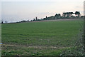
Farmland near Wanlip, Leicestershire
The land to the south of the Image rises steeply towards a narrow band of trees on the summit. The buildings just over the brow of the hill are Longslade Community College, the major secondary education provider for the Birstal area.
Image: © Kate Jewell
Taken: 24 Feb 2006
0.22 miles