IMAGES TAKEN NEAR TO
Meadow Lane, LEICESTER, LE4 4EU
Introduction
This page details the photographs taken nearby to Meadow Lane, LE4 4EU by members of the Geograph project.
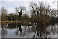
The Geograph project started in 2005 with the aim of publishing, organising and preserving representative images for every square kilometre of Great Britain, Ireland and the Isle of Man.

There are currently over 7.5m images from over14,400 individuals and you can help contribute to the project by visiting https://www.geograph.org.uk
Image Map
Images are licensed for reuse under creativecommons.org/licenses/by-sa/2.0
Notes
- Clicking on the map will re-center to the selected point.
- The higher the marker number, the further away the image location is from the centre of the postcode.
Image Listing (26 Images Found)
Images are licensed for reuse under creativecommons.org/licenses/by-sa/2.0
Image
Details
Distance
1
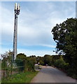
Mobile phone mast along Meadow Lane
This lane in Birstall leads to the Watermead Country Park North.
Image: © Mat Fascione
Taken: 5 Oct 2014
0.02 miles
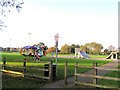
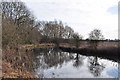
3
Watermead Country Park
There are 12 acres of lakes in this country park, it was created in the 1980s by flooding ex gravel pits. Now with the river Soar and the Grand Union canal passing through it is a haven for wildlife.
Image: © Ashley Dace
Taken: 12 Feb 2011
0.10 miles
4
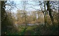
Watermead Country Park.
One of the many secluded lakes at the Watermead Country Park in Leicester.
Image: © Mat Fascione
Taken: 25 Mar 2007
0.11 miles
5
Watermead Country Park
There are 12 acres of lakes in this country park, it was created in the 1980s by flooding ex gravel pits. Now with the river Soar and the Grand Union canal passing through it is a haven for wildlife.
Image: © Ashley Dace
Taken: 12 Feb 2011
0.13 miles
6
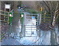
Flooded path in the Watermead Country Park
The River Soar has burst its banks.
Image: © Mat Fascione
Taken: 25 Nov 2012
0.14 miles
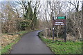
7
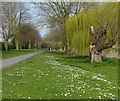
Path and cycleway along the River Soar
The path is heading towards Watermead Country Park North.
Image: © Mat Fascione
Taken: 30 Mar 2014
0.14 miles
9
Grand Union Canal
Running through Watermeads Country Park.
Image: © Ashley Dace
Taken: 12 Feb 2011
0.15 miles
10
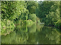
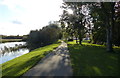
River Soar near Birstall in Leicestershire
The River Soar is seen here, looking downstream about half a mile north of Birstall Lock. The river flows by and through the extensive Watermead Country Park for about four miles north of Leicester. There are many large lakes which are former gravel pits. For some sections, the navigation reverts to canalised status, part of the Grand Union Canal (Leicester Section). https://www.leicscountryparks.org.uk/watermead-visitor-information/
https://en.wikipedia.org/wiki/Watermead_Country_Park
Image: © Roger Kidd
Taken: 26 Aug 2013
0.17 miles