IMAGES TAKEN NEAR TO
Cordelia Drive, LEICESTER, LE4 3PH
Introduction
This page details the photographs taken nearby to Cordelia Drive, LE4 3PH by members of the Geograph project.
The Geograph project started in 2005 with the aim of publishing, organising and preserving representative images for every square kilometre of Great Britain, Ireland and the Isle of Man.

There are currently over 7.5m images from over14,400 individuals and you can help contribute to the project by visiting https://www.geograph.org.uk
Image Map
Images are licensed for reuse under creativecommons.org/licenses/by-sa/2.0
Notes
- Clicking on the map will re-center to the selected point.
- The higher the marker number, the further away the image location is from the centre of the postcode.
Image Listing (10 Images Found)
Images are licensed for reuse under creativecommons.org/licenses/by-sa/2.0
Image
Details
Distance
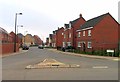
1
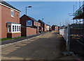
Houses under construction at Hallam Fields
Hallam Fields is a new housing development in Birstall, on the northern edge of Leicester.
Image: © Mat Fascione
Taken: 13 Mar 2016
0.06 miles
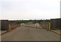
2
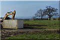
Farmland at Hallam Fields, Birstall
Soon to be part of a new housing development on the northern edge of Leicester.
Image: © Mat Fascione
Taken: 13 Mar 2016
0.13 miles
3
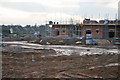
Hallam Fields, Birstal, Leicester
Once open pasture, this new development will take up two thirds of the square, filling the land between the existing houses which are just on the southern border with Image (in the background) and the A46 Western Bypass to the north, and the A6 to the east and the line of the Great Central Railway to the west.
Image: © Kate Jewell
Taken: 24 Feb 2006
0.15 miles
4
Hallam Fields, Birstal, Leicester
Leicester creeps ever outwards! The first buildings to be completed on this major residential development. The property type will range from apartments, mews style cottages and detached houses. The site will include shops, a primary school, light industrial units and recreational areas.
Image: © Kate Jewell
Taken: 24 Feb 2006
0.15 miles
6
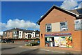
One Stop store, Hallam Fields Road, Birstall
Part of Tescos
Image: © Tim Heaton
Taken: 24 Feb 2024
0.19 miles
7
Birstall Meadow Road in Hallam Fields, Leicester
Hallam Fields is a new housing development in Birstall, on the northern edge of Leicester.
Image: © Mat Fascione
Taken: 13 Mar 2016
0.19 miles
8
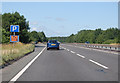
A46 parking area near Birstall
The road is now running west south west.
Image: © J.Hannan-Briggs
Taken: 18 Jul 2015
0.23 miles
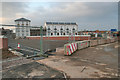
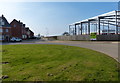
10

Bridge Green, Birstall (1)
The section parallel to Hallam Fields Road (right).
Image: © Richard Vince
Taken: 19 Jun 2021
0.24 miles