IMAGES TAKEN NEAR TO
Haydon Lane, LEICESTER, LE4 0ES
Introduction
This page details the photographs taken nearby to Haydon Lane, LE4 0ES by members of the Geograph project.
The Geograph project started in 2005 with the aim of publishing, organising and preserving representative images for every square kilometre of Great Britain, Ireland and the Isle of Man.

There are currently over 7.5m images from over14,400 individuals and you can help contribute to the project by visiting https://www.geograph.org.uk
Image Map
Images are licensed for reuse under creativecommons.org/licenses/by-sa/2.0
Notes
- Clicking on the map will re-center to the selected point.
- The higher the marker number, the further away the image location is from the centre of the postcode.
Image Listing (9 Images Found)
Images are licensed for reuse under creativecommons.org/licenses/by-sa/2.0
Image
Details
Distance
1
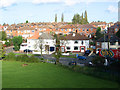
Housing off Anstey Lane
Photograph taken from Gorse Hill City Farm car park to give an elevated view of the roofscape of this estate. The trees are on the edge of Blackbird Road playing fields which dominate the NW quarter of the featured square. Anstey Lane just clips the square in the foreground.
Image: © Kate Jewell
Taken: 1 Nov 2005
0.09 miles
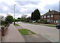
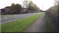
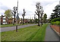
3
Roundabout at the junction of Avebury Avenue and Anstey Lane
Image: © Tim Glover
Taken: 6 Jul 2015
0.18 miles
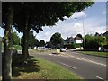
7
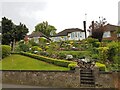
Terraced garden, Anstey Lane, Leicester
Fit posties needed for delivering mail along this lane.
Image: © Tim Heaton
Taken: 26 Apr 2022
0.24 miles
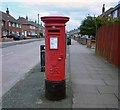
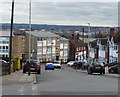
9
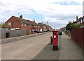
Cheltenham Road
Showing pillar box LE4 737!
Image: © Andrew Tatlow
Taken: 3 May 2013
0.25 miles