IMAGES TAKEN NEAR TO
Sylvan Street, LEICESTER, LE3 9GT
Introduction
This page details the photographs taken nearby to Sylvan Street, LE3 9GT by members of the Geograph project.
The Geograph project started in 2005 with the aim of publishing, organising and preserving representative images for every square kilometre of Great Britain, Ireland and the Isle of Man.

There are currently over 7.5m images from over14,400 individuals and you can help contribute to the project by visiting https://www.geograph.org.uk
Image Map
Images are licensed for reuse under creativecommons.org/licenses/by-sa/2.0
Notes
- Clicking on the map will re-center to the selected point.
- The higher the marker number, the further away the image location is from the centre of the postcode.
Image Listing (32 Images Found)
Images are licensed for reuse under creativecommons.org/licenses/by-sa/2.0
Image
Details
Distance
1
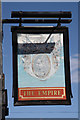
The Empire
Large pub on Fosse Road North, closed and with an uncertain future
Image: © Richard Croft
Taken: 24 Aug 2010
0.08 miles
2

Lidl store on Fosse Road North, Leicester
Built on the site of the former Empire public house. Image
Image: © Mat Fascione
Taken: 16 Jan 2016
0.09 miles
3
The sign of the Empire
Faded sign for the now-closed Empire pub http://www.geograph.org.uk/photo/2031289 on Fosse Road North
Image: © Richard Croft
Taken: 24 Aug 2010
0.10 miles
4
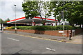
Esso petrol station at Pool Road / Fosse Road North junction
On the site of the demolished Fosse Cinema
Image: © Roger Templeman
Taken: 11 May 2018
0.10 miles
5
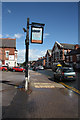
Fosse Road North
Leicester street scene by the Empire pub http://www.geograph.org.uk/photo/2031289
Image: © Richard Croft
Taken: 24 Aug 2010
0.11 miles
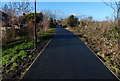
6

Stephenson Drive in Newfoundpool, Leicester
Image: © Mat Fascione
Taken: 13 Nov 2019
0.13 miles
7
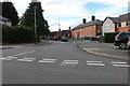
Swannington Road, Leicester
From Stephenson Drive
Image: © David Howard
Taken: 2 Aug 2022
0.14 miles
9
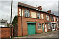
Paget Road housing and construction company premises
There is an OS benchmark Image on the wall of the left hand building between the brown gate and the black downpipe
Image: © Roger Templeman
Taken: 11 May 2018
0.17 miles
10
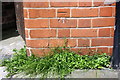
Benchmark on #83 Paget Road
Ordnance Survey cut mark benchmark described on the Bench Mark Database at https://www.bench-marks.org.uk/bm102382
Image: © Roger Templeman
Taken: 11 May 2018
0.17 miles