IMAGES TAKEN NEAR TO
St. Pauls Road, LEICESTER, LE3 9DE
Introduction
This page details the photographs taken nearby to St. Pauls Road, LE3 9DE by members of the Geograph project.
The Geograph project started in 2005 with the aim of publishing, organising and preserving representative images for every square kilometre of Great Britain, Ireland and the Isle of Man.

There are currently over 7.5m images from over14,400 individuals and you can help contribute to the project by visiting https://www.geograph.org.uk
Image Map
Images are licensed for reuse under creativecommons.org/licenses/by-sa/2.0
Notes
- Clicking on the map will re-center to the selected point.
- The higher the marker number, the further away the image location is from the centre of the postcode.
Image Listing (47 Images Found)
Images are licensed for reuse under creativecommons.org/licenses/by-sa/2.0
Image
Details
Distance
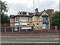
1
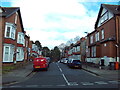
Bramley Road, Leicester
Off Glenfield Road.
Image: © Richard Vince
Taken: 9 Mar 2024
0.04 miles
2
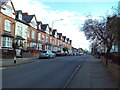
Glenfield Road, Leicester
Looking towards the city centre from its junction with Bramley Road.
Image: © Richard Vince
Taken: 9 Mar 2024
0.04 miles
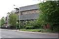
4
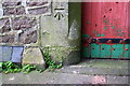
Benchmark on the north face of St Paul's Church
Ordnance Survey cut mark benchmark described on the Bench Mark Database at https://www.bench-marks.org.uk/bm102380
Image: © Roger Templeman
Taken: 11 May 2018
0.07 miles
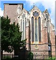
5
St Paul's Church, Glenfield Road
There is an OS benchmark Image on a stone to the left of the doors near the right hand side of the image
Image: © Roger Templeman
Taken: 11 May 2018
0.07 miles
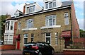
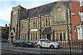
6
The Old Church of Saint Paul's, Leicester
Located at the corner of Glenfield Road and Kirby Road.
http://www.saintpaul.co.uk/index0.htm
Image: © Mat Fascione
Taken: 7 Jul 2007
0.08 miles
8

Grand Union Canal Leicester
View from a road bridge looking towards the point where a branch line from the Midland Railway's Swannington route crossed the canal on a wooden lifting bridge.The stone wall encloses a stonemason's yard.
Image: © Terry Roberts
Taken: Unknown
0.11 miles

10
St Andrew's Church, Leicester
On Fosse Road Central.
Image: © David Howard
Taken: 2 Aug 2022
0.13 miles