IMAGES TAKEN NEAR TO
Keepers Close, LEICESTER, LE3 8HW
Introduction
This page details the photographs taken nearby to Keepers Close, LE3 8HW by members of the Geograph project.
The Geograph project started in 2005 with the aim of publishing, organising and preserving representative images for every square kilometre of Great Britain, Ireland and the Isle of Man.

There are currently over 7.5m images from over14,400 individuals and you can help contribute to the project by visiting https://www.geograph.org.uk
Image Map
Images are licensed for reuse under creativecommons.org/licenses/by-sa/2.0
Notes
- Clicking on the map will re-center to the selected point.
- The higher the marker number, the further away the image location is from the centre of the postcode.
Image Listing (17 Images Found)
Images are licensed for reuse under creativecommons.org/licenses/by-sa/2.0
Image
Details
Distance
1
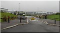
Warehouses at Optimus Point, Leicester
Image: © Mat Fascione
Taken: 14 Aug 2019
0.08 miles
3
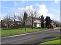
housing, Elm Tree Avenue
at corner of Kirby Road, Glenfield
Image: © Tammy Winand
Taken: 17 Feb 2006
0.16 miles
4
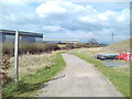
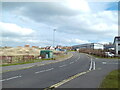
Roman Way, Optimus Point industrial estate
A permissive cycleway off Optimus Way, leading to Kirby Road, signposted to Groby and Ratby.
Image: © Richard Vince
Taken: 9 Mar 2024
0.17 miles

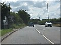
6

The Mill Lane, Glenfield
Taken from the Ivanhoe Trail, this is where the entrance road to the Widdowson and other depots crosses Rothley Brook.
Image: © John Welford
Taken: 26 Jul 2016
0.18 miles
7
Optimus Way, Optimus Point industrial estate
Looking towards the approximately contemporaneous housing development on the western side of Glenfield from close to its junction with Roman Avenue. There is no way through for motor traffic (except buses), however.
Image: © Richard Vince
Taken: 9 Mar 2024
0.18 miles
8
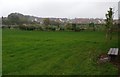
Mill Lane Open Space
Near the Mill Lane Industrial Estate and Rothley Brook.
Image: © Mat Fascione
Taken: 18 Oct 2017
0.19 miles
9
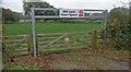
Entrance to the Mill Lane Open Space
Near the Mill Lane Industrial Estate and Rothley Brook.
Image: © Mat Fascione
Taken: 18 Oct 2017
0.20 miles
10
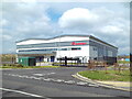
Sarstedt building, Optimus Point industrial estate
On the north side of Optimus Way.
Image: © Richard Vince
Taken: 9 Mar 2024
0.20 miles