IMAGES TAKEN NEAR TO
Thorpe Street, LEICESTER, LE3 5NQ
Introduction
This page details the photographs taken nearby to Thorpe Street, LE3 5NQ by members of the Geograph project.
The Geograph project started in 2005 with the aim of publishing, organising and preserving representative images for every square kilometre of Great Britain, Ireland and the Isle of Man.

There are currently over 7.5m images from over14,400 individuals and you can help contribute to the project by visiting https://www.geograph.org.uk
Image Map (Loading...)


Getting Data...Please wait
Leaflet Map data © OpenStreetMap
Images are licensed for reuse under creativecommons.org/licenses/by-sa/2.0
Notes
- Clicking on the map will re-center to the selected point.
- The higher the marker number, the further away the image location is from the centre of the postcode.
Image Listing (472 Images Found)
Images are licensed for reuse under creativecommons.org/licenses/by-sa/2.0
Image
Details
Distance
2
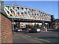
Braunstone Gate Railway Bridge
A real feature of this street, popular for its night life, is this disused bridge that is rather spectacular. It is unfortunate that at present, this bridge has fallen into disrepair and is almost certainly going to be dismantled in the near future.
Image: © Tim Hallam
Taken: 12 Jul 2005
0.03 miles
3
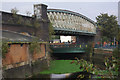
River Soar, Leicester
The river bends here to pass under both Braunstone Gate and the old Great Central railway bridge. Proposals to demolish the bridge, said to be in a poor condition, have met with opposition.
Image: © Stephen McKay
Taken: 14 Oct 2007
0.04 miles
4
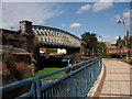
Great Central Railway bridge
This railway bridge over canal near centre of Leicester was known locally as the Bowstring Bridge. It originally carried the Great Central Railway into Leicester Central station.
The bridge was demolished in 2009 to make way for a sports centre. More information about it can be found at http://en.wikipedia.org/wiki/Braunstone_Gate_Bridge
Image: © Colin Lea
Taken: 15 Sep 2007
0.04 miles
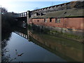
5
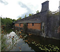
Factory along the Old River Soar in Leicester
Image: © Mat Fascione
Taken: 8 May 2020
0.04 miles
6
Abandoned railway, Leicester
The Great Central Railway was the last main line railway built in Victorian times. It ran from Manchester and Sheffield southwards through Nottingham, Leicester and Rugby to a London terminus at Marylebone. Opened in 1899, it was closed in the 1960s. Some of the route through Leicester can still be traced. Here at Braunstone Gate, the route of the railway was converted into a walkway and cycle path using the viaducts and bridges. The bridge across the road survived here until 2009.
More detail about the demolition of the bridge can be found at http://www.gcrleicester.info/html/braunstone_gate.html
Image: © Malc McDonald
Taken: 26 Feb 2011
0.05 miles
7
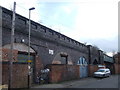
Railway arches, Leicester
The Great Central Railway was the last main line railway built in the Victorian era. It ran south from Sheffield and Manchester through Nottingham and Leicester, to a London terminus at Marylebone. It passed through Leicester to the west of the city centre. The route through the Braunstone Gate area was on a viaduct, parts of which survive such as here alongside Bede Street. The bridge in the background carried the railway across the River Soar.
Image: © Malc McDonald
Taken: 26 Feb 2011
0.05 miles
8

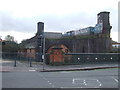
The Queen Elizabeth II Diamond Jubilee Leisure Centre
This £8 million leisure centre was built on the site of the former Bowstring Bridge.
Image: © Mat Fascione
Taken: 29 Dec 2014
0.05 miles
9
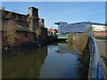
Old River Soar in Leicester
The Great Central Railway used to cross the river via the Bowstring Bridge, the bridge was demolished in 2009. See Image, for the same view taken 6 years earlier.
Image: © Mat Fascione
Taken: 29 Dec 2013
0.06 miles
10
Factory along the Old River Soar in Leicester
Image: © Mat Fascione
Taken: 29 Dec 2013
0.06 miles