IMAGES TAKEN NEAR TO
Tudor Road, LEICESTER, LE3 5HY
Introduction
This page details the photographs taken nearby to Tudor Road, LE3 5HY by members of the Geograph project.
The Geograph project started in 2005 with the aim of publishing, organising and preserving representative images for every square kilometre of Great Britain, Ireland and the Isle of Man.

There are currently over 7.5m images from over14,400 individuals and you can help contribute to the project by visiting https://www.geograph.org.uk
Image Map (Loading...)


Getting Data...Please wait
Leaflet Map data © OpenStreetMap
Images are licensed for reuse under creativecommons.org/licenses/by-sa/2.0
Notes
- Clicking on the map will re-center to the selected point.
- The higher the marker number, the further away the image location is from the centre of the postcode.
Image Listing (325 Images Found)
Images are licensed for reuse under creativecommons.org/licenses/by-sa/2.0
Image
Details
Distance
1
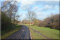
Leicester to Swannington Railway - West Bridge
A view from the cycle path on the former railway line.
Image: © Ashley Dace
Taken: 7 Dec 2011
0.03 miles
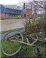
2
Leicester to Swannington Railway - Former Coal Wharf
All the times I have cycled here and never realised.
http://www.fipt.org.uk/digitalcanal/view-139
Image: © Ashley Dace
Taken: 7 Dec 2011
0.08 miles
3
Riverside development
There's a building going up on the western bank of the Soar.
Image: © Pierre Marshall
Taken: 26 Jan 2021
0.08 miles
4
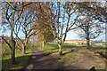
Leicester to Swannington Railway - West Bridge
A view of the former triangle (I think) with former goods yards to the right, passenger line to the station running behind me.
Image: © Ashley Dace
Taken: 7 Dec 2011
0.08 miles
5
Magnet Fishing
Various items dredged up from the River Soar/Grand Union Canal, in the Black Friars area of Leicester.
Image: © Mat Fascione
Taken: 16 Feb 2020
0.08 miles
6
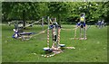
Outdoor gym equipment at The Rally Community Park
Taped off due to the Coronavirus (COVID-19) Pandemic.
Image: © Mat Fascione
Taken: 8 May 2020
0.09 miles
7
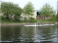
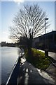
Scullers on the River Soar, Leicester
Heading upstream [locally south] at Black Friars.
Image: © Christine Johnstone
Taken: 5 May 2019
0.09 miles
8
Leicester to Swannington Railway - West Bridge
Just beyond West Bridge station, now a cycle path for around 1 mile.
Image: © Ashley Dace
Taken: 7 Dec 2011
0.09 miles
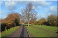
9
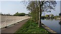
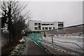
Path along the Grand Union Canal in Leicester
On the left is the site of the former Kirby and West dairy which has been recently demolished. A new 1,200 pupil secondary school will be built on the four-and-half acre site.
Image: © Mat Fascione
Taken: 10 Apr 2020
0.09 miles
10
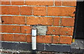
Benchmark on #43 Tudor Road
Ordnance Survey cut mark benchmark described on the Bench Mark Database at https://www.bench-marks.org.uk/bm102387
Image: © Roger Templeman
Taken: 11 May 2018
0.09 miles