IMAGES TAKEN NEAR TO
Tudor Road, LEICESTER, LE3 5HU
Introduction
This page details the photographs taken nearby to Tudor Road, LE3 5HU by members of the Geograph project.
The Geograph project started in 2005 with the aim of publishing, organising and preserving representative images for every square kilometre of Great Britain, Ireland and the Isle of Man.

There are currently over 7.5m images from over14,400 individuals and you can help contribute to the project by visiting https://www.geograph.org.uk
Image Map
Images are licensed for reuse under creativecommons.org/licenses/by-sa/2.0
Notes
- Clicking on the map will re-center to the selected point.
- The higher the marker number, the further away the image location is from the centre of the postcode.
Image Listing (294 Images Found)
Images are licensed for reuse under creativecommons.org/licenses/by-sa/2.0
Image
Details
Distance
1
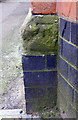
Benchmark on building at junction of Nugent Street and Tudor Road
Ordnance Survey cut mark benchmark described on the Bench Mark Database at https://www.bench-marks.org.uk/bm102386
Image: © Roger Templeman
Taken: 11 May 2018
0.04 miles
2
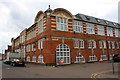
Building at Tudor Road / Nugent Street junction housing Tudor Studios
There is an OS benchmark Image on the near end of the small jut near the corner on the left hand face of the building, a former hosiery mill.
Image: © Roger Templeman
Taken: 11 May 2018
0.04 miles
6
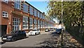
Former shoe factory on Vernon Street, Leicester
This former shoe factory was built in 1901, it has been converted into Tudor Studios student accommodation.
Image: © Mat Fascione
Taken: 24 Apr 2020
0.06 miles
7
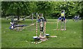
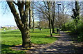
Outdoor gym equipment at The Rally Community Park
Taped off due to the Coronavirus (COVID-19) Pandemic.
Image: © Mat Fascione
Taken: 8 May 2020
0.06 miles
8
Leicester to Swannington Railway - West Bridge
Former goods yard next to the canal.
Image: © Ashley Dace
Taken: 7 Dec 2011
0.06 miles
9
Leicester to Swannington Railway - West Bridge
A view of the former triangle (I think) with former goods yards to the right, passenger line to the station running behind me.
Image: © Ashley Dace
Taken: 7 Dec 2011
0.07 miles
10
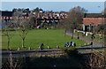
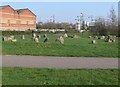
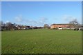
The Rally Community Park
The houses in the background are along Tudor Road.
Image: © Mat Fascione
Taken: 18 Jan 2015
0.07 miles