IMAGES TAKEN NEAR TO
Bath Lane, LEICESTER, LE3 5DY
Introduction
This page details the photographs taken nearby to Bath Lane, LE3 5DY by members of the Geograph project.
The Geograph project started in 2005 with the aim of publishing, organising and preserving representative images for every square kilometre of Great Britain, Ireland and the Isle of Man.

There are currently over 7.5m images from over14,400 individuals and you can help contribute to the project by visiting https://www.geograph.org.uk
Image Map
Images are licensed for reuse under creativecommons.org/licenses/by-sa/2.0
Notes
- Clicking on the map will re-center to the selected point.
- The higher the marker number, the further away the image location is from the centre of the postcode.
Image Listing (641 Images Found)
Images are licensed for reuse under creativecommons.org/licenses/by-sa/2.0
Image
Details
Distance
1
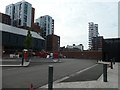
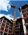
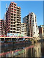
Redevelopment along Bath Lane
In the Black Friars area of Leicester, on the east bank of the River Soar.
Image: © Christine Johnstone
Taken: 5 May 2019
0.01 miles
2
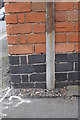
Benchmark on building at Bath Lane / Blackfriars Street junction
Ordnance Survey cut mark benchmark described on the Bench Mark Database at http://www.bench-marks.org.uk/bm57336
Image: © Roger Templeman
Taken: 22 Apr 2014
0.02 miles
3
Building at Bath Lane / Blackfriars Street junction
There is an OS benchmark Image on the near corner of the building on the Bath Lane face right of the cable duct
Image: © Roger Templeman
Taken: 22 Apr 2014
0.02 miles
4
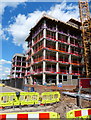
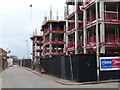
Construction along Bath Lane
Part of a 601 bedroom student accommodation development being built on the rundown area of Black Friars.
Compare with Image which was taken a month earlier.
Image: © Mat Fascione
Taken: 26 Apr 2015
0.02 miles
5
Construction along Bath Lane
Part of a 601 bedroom student accommodation development being built on the rundown area of Black Friars.
Image: © Mat Fascione
Taken: 26 Apr 2015
0.02 miles
6
Construction along Bath Lane
Part of a 601 bedroom student accommodation development being built on the rundown area of Black Friars.
Image: © Mat Fascione
Taken: 23 Mar 2015
0.02 miles
7
Construction along Bath Lane
Part of a 601 bedroom student accommodation development being built on the rundown area of Black Friars.
Image: © Mat Fascione
Taken: 26 Sep 2015
0.02 miles
8
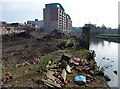
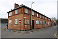
Wasteland along the Grand Union Canal at Black Friars
Image: © Mat Fascione
Taken: 13 Mar 2016
0.02 miles
9
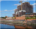
Apartments under construction
Along the Grand Union Canal in the Black Friars area of Leicester.
Image: © Mat Fascione
Taken: 27 Oct 2019
0.03 miles
10
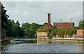
Grand Union Canal/River Soar in Leicester
This is a telephoto assisted image of the River Soar north of West Bridge, although here it is still a canalised section (Grand Union Canal) built through the city in the late nineteenth century to improve flood control. Ahead are the derelict Friars Mill buildings, which will eventually be converted into smart apartments, when the finance is forthcoming!! Work is "intermittent".
Image: © Roger Kidd
Taken: 25 Aug 2013
0.03 miles