IMAGES TAKEN NEAR TO
Limekiln Road, LE3 5DD
Introduction
This page details the photographs taken nearby to Limekiln Road, LE3 5DD by members of the Geograph project.
The Geograph project started in 2005 with the aim of publishing, organising and preserving representative images for every square kilometre of Great Britain, Ireland and the Isle of Man.

There are currently over 7.5m images from over14,400 individuals and you can help contribute to the project by visiting https://www.geograph.org.uk
Image Map
Images are licensed for reuse under creativecommons.org/licenses/by-sa/2.0
Notes
- Clicking on the map will re-center to the selected point.
- The higher the marker number, the further away the image location is from the centre of the postcode.
Image Listing (456 Images Found)
Images are licensed for reuse under creativecommons.org/licenses/by-sa/2.0
Image
Details
Distance
1
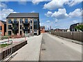
Limekiln Road at Frog Island, Leicester
Part of the Waterside development of 288 contemporary homes and apartments.
Image: © Mat Fascione
Taken: 5 May 2024
0.01 miles
2
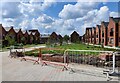
Open space at Waterside
The Waterside is a new development of 288 contemporary homes and apartments in the Frog Island area of Leicester.
Image: © Mat Fascione
Taken: 5 May 2024
0.02 miles
3
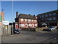
The Ship Inn, Soar Lane, Leicester
First Leicester pub on Cycle Route 6
Image: © Tim Heaton
Taken: 26 Feb 2012
0.02 miles
4
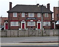
The Ship Inn, Soar Lane
Former public house in Frog Island, it closed in 2013.
Image: © Mat Fascione
Taken: 3 Apr 2014
0.03 miles
5
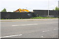
Boarded up development site on SW side of Northgate Street
Previously a railway bridge crossed here with railway tracks behind
Image: © Roger Templeman
Taken: 11 May 2018
0.03 miles
6

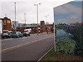
Leicester - City Centre (beyond the Ring Rd)
The Ship Inn on Soar Lane prior to opening time. Presumably many of its customers in the past will have been employees in nearby hosiery factories, like the one behind it perhaps? A stretch of the Grand Union canal lies 2-3 minutes walk from here behind the photographer and in the opposite direction (1 min walk away) is the Northgate St/Highcross St junction with Sanvey Gate, all of which sit just outside the inner ring road.
Image: © David Hallam-Jones
Taken: 31 Mar 2012
0.04 miles
7
Leicester - City Centre
Instead of leaving this demolition site at the junction of Soar Lane with Highcross Street untidy and ripe for misuse by fly-tippers and squatters Leicester City Council has arranged for a frieze of local scenes created by artist Helen Saunders to be mounted on these hoardings along this stretch of road as it enters the city centre. The Church in the distance is St Ann's, a decommissioned but carefully preserved Norman church dating from the 13th century. It is situated in High Cross Street (Leicester's original High Street). High Cross shopping centre is also visible on the horizon sporting a greeny-grey patterned side elevation.
Image: © David Hallam-Jones
Taken: 31 Mar 2012
0.04 miles
8
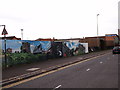
Leicester - City Centre
Instead of leaving this demolition site untidy and ripe for misuse by fly-tippers and squatters Leicester City Council has arranged for a frieze of local scenes created by artist Helen Saunders to be mounted on these hoardings along this particular stretch of Northgate Street, NG1 as it leaves the city centre.
Image: © David Hallam-Jones
Taken: 31 Mar 2012
0.04 miles
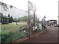
9
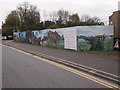
Leicester - City Centre
A stretch of artistically decorated hoardings positioned around a demolition site at the side of Northgate Street as it enters the city centre. Its junction with a minor road - Soar Lane - can be seen at the end of the hoardings. This high quality photographic work was commissioned from artist Helen Saunders and represents an impressive attempt at keeping the city looking cared-for in the midst of on-going demolition and redevelopment work instead of leaving the site untidy and ripe for misuse by fly-tippers and squatters.
Image: © David Hallam-Jones
Taken: 31 Mar 2012
0.04 miles
10
Leicester - City Centre
An image of Abbey Park has been transposed onto these hoardings at the junction of this minor road - Soar Lane - with Highcross St/Northgate Street (a continuous major road) near the city centre. Instead of leaving the demolition site untidy and ripe for misuse by fly-tippers and squatters Leicester City Council has arranged for a mounted frieze of local scenes created by artist Helen Saunders to be used as a very aesthetically pleasing barrier near to one of the entry points into the city.
Image: © David Hallam-Jones
Taken: 31 Mar 2012
0.04 miles