IMAGES TAKEN NEAR TO
Jarvis Street, LE3 5BQ
Introduction
This page details the photographs taken nearby to Jarvis Street, LE3 5BQ by members of the Geograph project.
The Geograph project started in 2005 with the aim of publishing, organising and preserving representative images for every square kilometre of Great Britain, Ireland and the Isle of Man.

There are currently over 7.5m images from over14,400 individuals and you can help contribute to the project by visiting https://www.geograph.org.uk
Image Map (Loading...)


Getting Data...Please wait
Leaflet Map data © OpenStreetMap
Images are licensed for reuse under creativecommons.org/licenses/by-sa/2.0
Notes
- Clicking on the map will re-center to the selected point.
- The higher the marker number, the further away the image location is from the centre of the postcode.
Image Listing (515 Images Found)
Images are licensed for reuse under creativecommons.org/licenses/by-sa/2.0
Image
Details
Distance
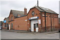
1

Benchmark on building at Jarvis Street / Soar Lane junction
Ordnance Survey cut mark benchmark described on the Bench Mark Database at http://www.bench-marks.org.uk/bm57245
Image: © Roger Templeman
Taken: 22 Apr 2014
0.01 miles
2
GAZ Autoschool, Jarvis Street at Soar Lane junction
There is an OS benchmark Image on the near corner of the building on the Soar Lane face
Image: © Roger Templeman
Taken: 22 Apr 2014
0.01 miles
3
Site of the former Ship Inn
The Ship Inn was a former public house that stood on Soar Lane. It closed in 2013, and stood derelict for several years before being demolished, part of the wider regeneration of the Black Friars area of Leicester.
Image
Image: © Mat Fascione
Taken: 26 Apr 2020
0.01 miles
4
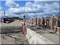
Houses under construction along Soar Lane
The houses are being built on the site of the former Ship Inn.
Image
Image: © Mat Fascione
Taken: 16 Apr 2021
0.02 miles
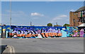
5

Graffiti along Jarvis Street, Leicester
Black Friars is an area of the city of Leicester next to the River Soar, it is named after a former Dominican friary. The area is being redeveloped with a mixture of apartments and offices.
Image: © Mat Fascione
Taken: 16 Feb 2020
0.02 miles
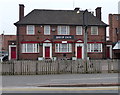
6

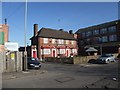
Leicester - City Centre (beyond the Ring Rd)
The Ship Inn on Soar Lane prior to opening time. Presumably many of its customers in the past will have been employees in nearby hosiery factories, like the one behind it perhaps? A stretch of the Grand Union canal lies 2-3 minutes walk from here behind the photographer and in the opposite direction (1 min walk away) is the Northgate St/Highcross St junction with Sanvey Gate, all of which sit just outside the inner ring road.
Image: © David Hallam-Jones
Taken: 31 Mar 2012
0.02 miles
7
The Ship Inn, Soar Lane
Former public house in Frog Island, it closed in 2013.
Image: © Mat Fascione
Taken: 3 Apr 2014
0.03 miles
8
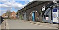
Jarvis Street in Leicester
The run down Black Friars area of Leicester, currently being redeveloped.
Image: © Mat Fascione
Taken: 24 Mar 2019
0.03 miles
9
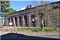
Railway Viaduct and Industrial Estate
This viaduct supported the Great Central railway Leicester central station. The line closed in 1969.
Image: © Ashley Dace
Taken: 17 Oct 2010
0.03 miles
10
The Ship Inn, Soar Lane, Leicester
First Leicester pub on Cycle Route 6
Image: © Tim Heaton
Taken: 26 Feb 2012
0.04 miles